More actions
इससे बड़ा रेसोल्यूशन उपलब्ध नहीं हैं।
Mongol_Empire_map.gif (७५२ × ५९१ चित्रतत्व, संचिका का आकार: १६२ KB, माइम प्रकार: image/gif, चक्रित, ९ ढाँचे, ९.० s)
सारांश
| विवरण |
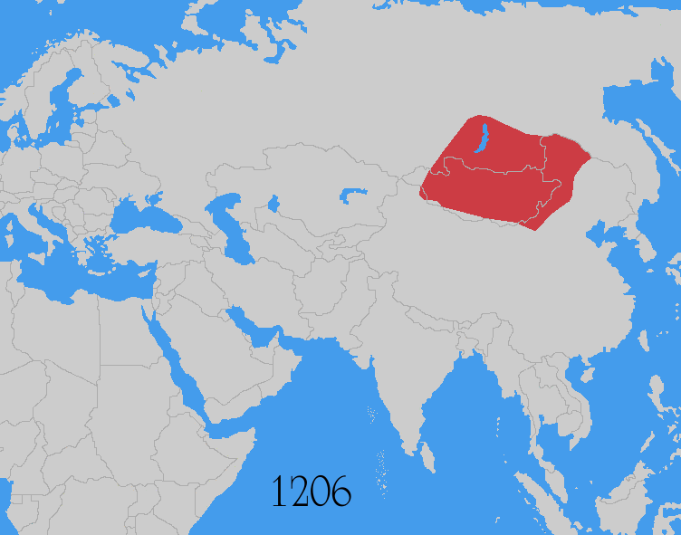
Map showing changes in borders of the Mongol Empire from founding by Genghis Khan in 1206, Genghis Khan's death in 1227 to the rule of Kublai Khan (1260–1294). (Uses modern day borders) Mongol Empire
By 1294 the empire had split into: Yuan Dynasty (Great Khanate) |
| दिनांक | |
| स्रोत | Based on the freely licenced Image:Genghis khan empire at his death.png using information from maps of the Mongol Empire in atlases and on the web such as [1], [2], [3], [4], [5]. Made in Photoshop and Painter. |
| लेखक | User:Astrokey44 |
| अनुमति (इस चित्र का पुनः उपयोग करना) |
self made |
| दूसरे संस्करण |
इस फ़ाइल के व्युत्पन्न कार्य: Mongol Empire map 2.gif other maps on commons - same animation but with alternative colours, greatest extent, Mongol dominions, 1294 |
![[1]](http://www.silk-road.com/maps/images/mongol.jpg)
![[2]](http://www.loyno.edu/~seduffy/MapImages/MongolEmpire-display.jpg)
![[3]](http://www.siu.edu/~dfll/Chinese/mongol.jpg)
![[4]](http://www.allempires.com/empires/mongol/mongolempire_map.jpg)
![[5]](http://www.tiscali.co.uk/reference/encyclopaedia/hutchinson/images/c01786.jpg)
लाइसेंस
मैं, इस कार्य का/की कॉपीराइट धारक, इसे निम्न लाइसेंसों के अंतर्गत प्रकाशित करता/करती हूँ:

|
इस दस्तावेज़ को Free Software Foundation द्वारा प्रकाशित GNU मुक्त प्रलेख लाइसेंस के संस्करण 1.2 या नए (बिना किसी अपरिवर्तनीय अनुभागों और अगले या पिछले आवरण के टेक्स्ट के) के अंतर्गत प्रतिलिपि बनाने, बाँटने और/या बदलने की अनुमति प्रदान की जाती है। इस लाइसेंस की एक प्रतिलिपि GNU मुक्त प्रलेख लाइसेंस नामक अनुभाग में शामिल है। |
| इस फ़ाइल को क्रिएटिव कॉमन्स श्रेय-समानसांझा 3.0 अनरिपोर्टेड लाइसेंस के अंतर्गत लाइसेंस किया गया है। | ||
| ||
| This licensing tag was added to this file as part of the GFDL licensing update. |
इस फ़ाइल को क्रिएटिव कॉमन्स श्रेय-समानसांझा 2.5 साधारण, 2.0 साधारण और 1.0 साधारण लाइसेंस के अंतर्गत लाइसेंस किया गया है।
- आप खुलकर:
- बाँट सकते हैं – रचना की प्रतिलिपि बना सकते हैं, बाँँट सकते हैं और संचारित कर सकते हैं
- रीमिक्स कर सकते हैं – कार्य को अनुकूलित कर सकते हैं
- निम्नलिखित शर्तों के अंतर्गत:
- श्रेय – यह अनिवार्य है कि आप यथोचित श्रेय प्रदान करें, लाइसेंस की कड़ी प्रदान करें, और अगर कोई बदलाव हुए हों तो उन्हें इंगित करें। आप ऐसा किसी भी उचित तरीके से कर सकते हैं, लेकिन किसी भी तरह उससे यह नहीं संकेत नहीं किया जाना चाहिए कि लाइसेंसधारी द्वारा आपको अथवा आपके इस प्रयोग का समर्थन किया जा रहा हो।
- समानसांझा – यदि आप सामग्री को रीमिक्स करते हैं, बदलते हैं, या उस पर आधारित कुछ बनाते हैं, तो आपको अपने योगदान को समान या संगत लाइसेंस के तहत वितरित करना होगा।
आप अपना पसंद का लाइसेंस चुन सकते हैं।
Additional sources
- For the Ilkhanate: Roolvink, R. (२००७) Historical Atlas of the Muslim Peoples, Taylor and Francis, p. 26 ISBN: 9780415440943.
- Mongol dominions, 1226–1405: Shepherd, William Robert; C.S. Hammond & Company (१९६४) Historical atlas, Barnes & Noble, p. 92
- McKitterick, Rosamond (२००३) Atlas of the medieval world, Oxford University Press, pp. 174–175 ISBN: 9780195221589.
| ऐनोटेशन्स | इस चित्र को ऐनोटेट किया गया है: कॉमन्स पर ऐनोटेशन्स देखें |
चित्र का इतिहास
चित्र पुराने समय में कैसी दिखती थी यह जानने के लिए दिनांक/समय पर क्लिक करें।
| दिनांक/समय | थंबनेल | आकार | सदस्य | टिप्पणी | |
|---|---|---|---|---|---|
| वर्तमान | १५:०७, ३० जुलाई २०१४ | | ७५२ × ५९१ (१६२ KB) | wikimediacommons>Sven Manguard | As per Commons:Overwriting existing files |
चित्र का उपयोग
यह पृष्ठ इस चित्र का इस्तेमाल करता है: