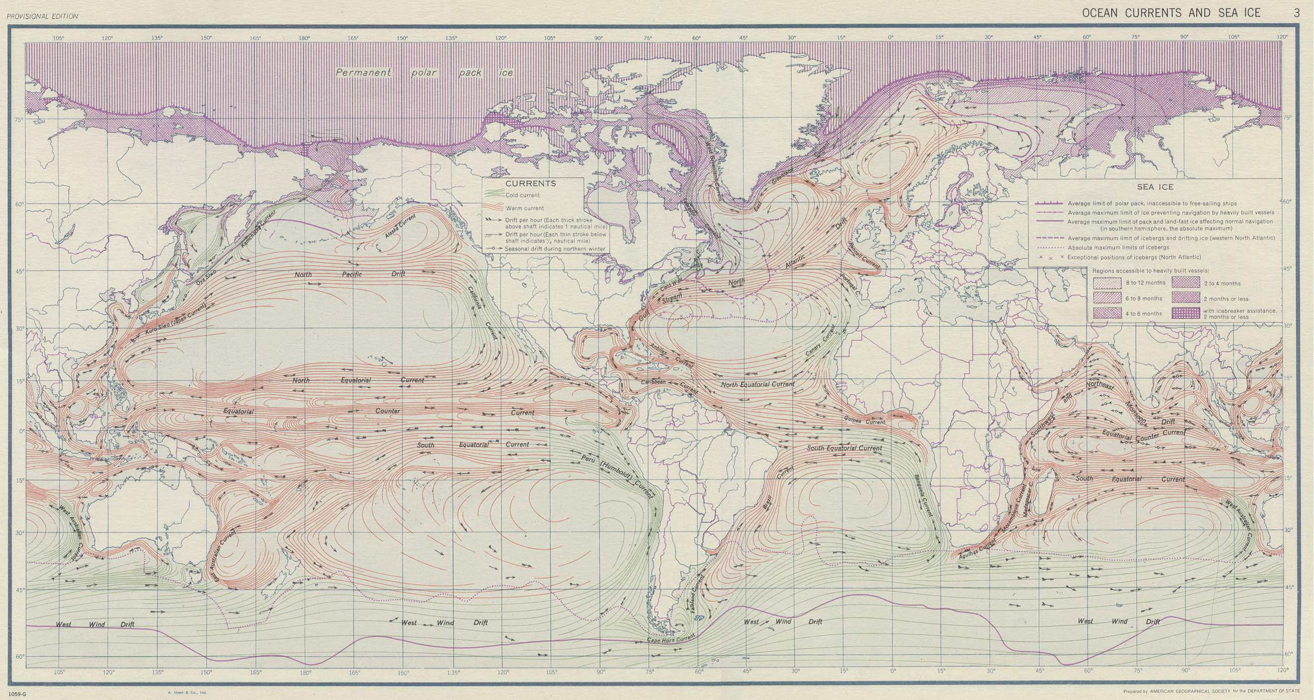
चित्र:Ocean currents 1943 (borderless).png
अंगूठाकार बनाने में त्रुटि हुई: फ़ाइल गायब है
दूसरा रेसोल्यूशन: २,५७७ × १,३०६ पिक्सेल।
मूल फ़ाइल (२,५७७ × १,३०६ पिक्सेल, फ़ाइल का आकार: २.७५ MB, MIME प्रकार: image/png)

|
इस फ़ाइल को Ocean currents 1943 (borderless)3.png द्वारा अधिक्रमित कर दिया गया है। दूसरे फ़ाइल का इस्तेमाल करने सुझाया जाता है। कृपया ध्यान रखें कि अधिक्रमित चित्रों को हटाने के लिए अनुमति की ज़रबरत है।
|
3.png)
|

|
इस meteorology चित्र को वेक्टर ग्राफ़िक्स की मदद से एक SVG फ़ाइल के रूप में पुनः निर्मित किया जा सकता है। इसके कई फ़ायदे हैं; अधिक जानकारी के लिए Commons:Media for cleanup देखें। अगर इस चित्र का एक SVG रूप उपलब्ध है, कृपया उसे अपलोड करें और उसके बाद इस साँचे को
{{vector version available|नए चित्र का नाम}} से बदल दें।
SVG फ़ाइल का नाम "Ocean currents 1943 (borderless).svg" रखना अनुशंसित है—ऐसा करने पर Vector version available (या Vva) साँचे पर नए चित्र का नाम वाले पैरामीटर की ज़रूरत नहीं पड़ेगी। |
सारांश
| विवरणOcean currents 1943 (borderless).png | Ocean Currents and Sea Ice from Atlas of World Maps, United States Army Service Forces, Army Specialized Training Division. Army Service Forces Manual M-101 (1943). It could be drawn by the Miller cylindrical projection announced in 1942. | ||||
| दिनांक | |||||
| स्रोत | http://www.lib.utexas.edu/maps/world_maps/ocean_currents_1943.jpg | ||||
| लेखक | Original by US army, successively modified by Jack · talk · (removed borders and rivers) | ||||
| अनुमति (इस फ़ाइल का पुनः उपयोग करना) |
|
||||
| दूसरे संस्करण |
इस फ़ाइल के व्युत्पन्न कार्य: Ocean currents 1943 for colorblind users.png |


.png)
.png)

Captions
Add a one-line explanation of what this file represents
फ़ाइल का इतिहास
फ़ाइल पुराने समय में कैसी दिखती थी यह जानने के लिए दिनांक/समय पर क्लिक करें।
| दिनांक/समय | अंगूठाकार | आकार | सदस्य | टिप्पणी | |
|---|---|---|---|---|---|
| वर्तमान | २३:५७, ७ अप्रैल २००८ | अंगूठाकार बनाने में त्रुटि हुई: फ़ाइल गायब है | २,५७७ × १,३०६ (२.७५ MB) | smartcommons>Jrockley | fix finland |
चित्र का उपयोग
कोई भी ऐसा पृष्ठ नहीं है जो इस चित्र का प्रयोग कर रहा हो।
.png)