चित्र:Alignment Official Pakistan map 1962.jpg

मूल फ़ाइल (६०० × ६१६ पिक्सेल, फ़ाइल का आकार: ५९ KB, MIME प्रकार: image/jpeg)
सारांश

|
इस historical map चित्र को वेक्टर ग्राफ़िक्स की मदद से एक SVG फ़ाइल के रूप में पुनः निर्मित किया जा सकता है। इसके कई फ़ायदे हैं; अधिक जानकारी के लिए Commons:Media for cleanup देखें। अगर इस चित्र का एक SVG रूप उपलब्ध है, कृपया उसे अपलोड करें और उसके बाद इस साँचे को
{{vector version available|नए चित्र का नाम}} से बदल दें।
SVG फ़ाइल का नाम "Alignment Official Pakistan map 1962.svg" रखना अनुशंसित है—ऐसा करने पर Vector version available (या Vva) साँचे पर नए चित्र का नाम वाले पैरामीटर की ज़रूरत नहीं पड़ेगी। |


| विवरणAlignment Official Pakistan map 1962.jpg |
English: Map depicting the official alignment of the northern border of Kashmir in 1962 according to the Government of Pakistan |
| दिनांक | |
| स्रोत | Sino Pakistan "Agreement", March 2, 1963 "Some facts" published by the Government of India, Ministry of External Affairs |
| लेखक | The Government of India, Ministry of External Affairs |
| कैमरा स्थान |  | यह और अन्य आसपास की छवियों यहां पर देखें: ओपन स्ट्रीट मैप |  36.470000; 76.160000 36.470000; 76.160000 |
|---|

The area pertains to the Cis-Kuen Lun Tract in northern Kashmir, the area in northern Kashmir which has been either annexed by the Chinese or is part of the area ceded by Pakistan to the Chinese. The Northern border of the Cis-Kuen Lun Tract is the area of Dafdar in the area of the Taghdumbash Pamir and Mariom Pamir and the mountain passes in northern Kashmir including inter alia the Kukalang Pass, Yangi Pass to the north of the Raskam area in Kanjut , the Kilian Pass, the Sanju-La Pass and the Hindutash Pass. The Government of Pakistan had published an official map depicting the alignment of the northern Border of Kashmir in 1962 which depicted much of the Cis-Kuen Lun Tract as part of Kashmir and the Times Atlas had predominantly depicted the Cis-Kuen Lun Tract as a part of Kashmir under the caption "Undefined Frontier area" in 1959.
लाइसेंस
| Public domainPublic domainfalsefalse |

|
यह कार्य भारत में सार्वजनिक डोमेन में है क्योंकि इसका कॉपीराइट समाप्त हो चुका है।
भारतीय प्रतिलिप्याधिकार अधिनियम, पहली बार भारत में प्रकाशित कार्यों पर लागू होता है। 2012 के अधिनियम क्रमांक 27 तक संशोधित भारतीय प्रतिलिप्याधिकार अधिनियम, 1957 (अध्याय V, धारा 25) के अनुसार:
 You must also include a United States public domain tag to indicate why this work is in the public domain in the United States. You must also include a United States public domain tag to indicate why this work is in the public domain in the United States.
|
 |
– India public domain images and sounds, 60 years after the end of the year of first publication, The subject matter of the photo or recording is also not protected by copyright.
Captions
फ़ाइल का इतिहास
फ़ाइल पुराने समय में कैसी दिखती थी यह जानने के लिए दिनांक/समय पर क्लिक करें।
| दिनांक/समय | अंगूठाकार | आकार | सदस्य | टिप्पणी | |
|---|---|---|---|---|---|
| वर्तमान | १९:२६, २१ अप्रैल २०१६ | 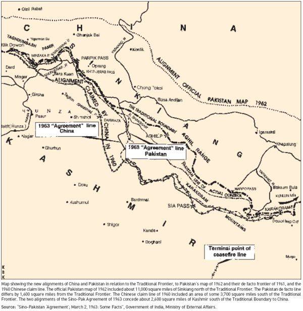 | ६०० × ६१६ (५९ KB) | smartcommons>Hindutashravi | User created page with UploadWizard |
चित्र का उपयोग
कोई भी ऐसा पृष्ठ नहीं है जो इस चित्र का प्रयोग कर रहा हो।
