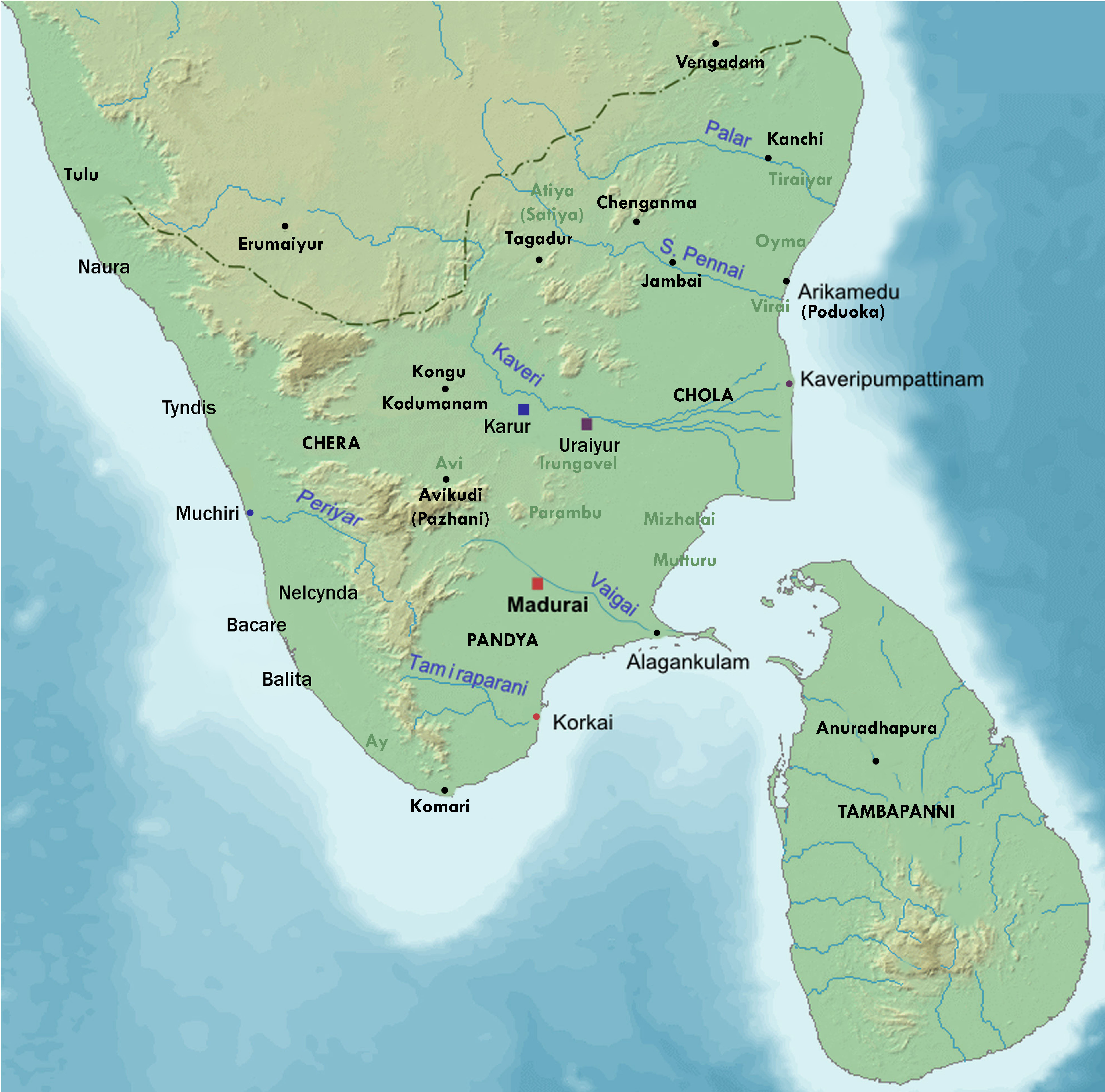
चित्र:Ancient tamilakam ports.png
अंगूठाकार बनाने में त्रुटि हुई: १२.५ MP से अधिक आयाम वाली फ़ाइल
दूसरा रेसोल्यूशन: ४,९८४ × ४,९२५ पिक्सेल।

मूल फ़ाइल (४,९८४ × ४,९२५ पिक्सेल, फ़ाइल का आकार: ९ MB, MIME प्रकार: image/png)

सारांश
| विवरणAncient tamilakam ports.png | Map showing the important port cities of ancient Tamil country and its approximate northern boundary |
| दिनांक | |
| स्रोत |
Source of map: http://www2.demis.nl/mapserver/mapper.asp (mention : "Disclaimer: With this statement DEMIS BV grants you permission to freely copy the PNG images returned by our server and use them for your own purposes, including web pages. We would appreciate a reference to our server but such a reference is not required, nor do we take responsibility for the accuracy or quality of the maps". at http://www2.demis.nl/mapserver/DataSrc.htm) Modified by me using Inkscape. |
| लेखक | Lotlil |
लाइसेंस
| Public domainPublic domainfalsefalse |

|
इस कार्य को इसके लेखक, Lotlil द्वारा सार्वजनिक डोमेन में प्रकाशित किया गया है। यह पूरे विश्व में लागू होता है। कुछ देशों में यह कानूनी तौर पर नहीं हो सकता है; ऐसा हो तो: Lotlil सभी को इस कार्य का इस्तेमाल किसी भी उद्देश्य से, बिना किसी बाधाओं के इन शर्तों के कानून द्वारा अनिवार्य किए तक करने की अनुमति देता/देती हैं। |
Captions
Add a one-line explanation of what this file represents
फ़ाइल का इतिहास
फ़ाइल पुराने समय में कैसी दिखती थी यह जानने के लिए दिनांक/समय पर क्लिक करें।
| दिनांक/समय | अंगूठाकार | आकार | सदस्य | टिप्पणी | |
|---|---|---|---|---|---|
| वर्तमान | १२:५४, २९ नवम्बर २०१९ | अंगूठाकार बनाने में त्रुटि हुई: १२.५ MP से अधिक आयाम वाली फ़ाइल | ४,९८४ × ४,९२५ (९ MB) | smartcommons>StephenPaa | Added more locations |
चित्र का उपयोग
कोई भी ऐसा पृष्ठ नहीं है जो इस चित्र का प्रयोग कर रहा हो।
