चित्र:Canada topo.jpg

इस पूर्वावलोकन का आकार: २२० × १९० पिक्सेल। दूसरे रेसोल्यूशन्स: २७८ × २४० पिक्सेल | १,४०० × १,२११ पिक्सेल।
मूल फ़ाइल (१,४०० × १,२११ पिक्सेल, फ़ाइल का आकार: ७९१ KB, MIME प्रकार: image/jpeg)

सारांश
| विवरणCanada topo.jpg |
A topographic map of Canada, in polar projection (for 90° W), showing elevations shaded from green to brown (higher), with elevation-legend overlaid at lower left. Nearby countries are shaded darker (compare elevation shades at Canadian borders). The image is centered over longitude 90° W, with longitude meridians at 15-degree intervals apart, and latitude parallels also 15-degree. The boundaries are roughly from longitude 10°W to 177°W, and latitude 40°N to 84°N (above northern-most Alert, Canada 82°28′N, 62°30′W). |
| दिनांक | 14-April-2006 (English Wikipedia image of 7-July-2005) |
| स्रोत | From English Wikipedia image of 7-July-2005, same name: en:Image:Canada topo.jpg (which now points here to Commons). |
| लेखक | User:Anchjo (from en:Wikipedia User:Captain_Blood) |
| दूसरे संस्करण | इस फ़ाइल के व्युत्पन्न कार्य: Dawson Route topo.jpg |


लाइसेंस
 |
The map has been created with the Generic Mapping Tools: https://www.generic-mapping-tools.org/ using one or more of these public-domain datasets for the relief:
|

|
इस दस्तावेज़ को Free Software Foundation द्वारा प्रकाशित GNU मुक्त प्रलेख लाइसेंस के संस्करण 1.2 या नए (बिना किसी अपरिवर्तनीय अनुभागों और अगले या पिछले आवरण के टेक्स्ट के) के अंतर्गत प्रतिलिपि बनाने, बाँटने और/या बदलने की अनुमति प्रदान की जाती है। इस लाइसेंस की एक प्रतिलिपि GNU मुक्त प्रलेख लाइसेंस नामक अनुभाग में शामिल है।http://www.gnu.org/copyleft/fdl.htmlGFDLGNU Free Documentation Licensetruetrue |
  
|
इस फ़ाइल को क्रिएटिव कॉमन्स श्रेय-समानसांझा 3.0 अनांतरित लाइसेंस के अंतर्गत लाइसेंस किया गया है। | |
| ||
| This licensing tag was added to this file as part of the GFDL licensing update.http://creativecommons.org/licenses/by-sa/3.0/CC BY-SA 3.0Creative Commons Attribution-Share Alike 3.0truetrue |

मूल अपलोड लॉग
- http://upload.wikimedia.org/wikipedia/en/d/d7/Canada topo.jpg[मृत कड़ी] (14:36, 7 July 2005) . . User:Captain Blood (Captain Blood) (User talk:Captain Blood (Talk) ) . . 1400x1211 (810081 bytes) ({GMT})

Captions
Add a one-line explanation of what this file represents
A topographic map of Canada in a polar projection (for 90° W), showing elevations shaded from green to brown (higher), with an elevation legend overlaid in the lower left corner. Nearby countries are darker.
Topograficzna mapa Kanady w rzucie biegunowym (dla 90° W), pokazująca wzniesienia zacieniowane od zielonego do brązowego (wyżej), z nałożoną legendą elewacji w lewym dolnym rogu. Kraje w pobliżu są ciemniejsze (
फ़ाइल का इतिहास
फ़ाइल पुराने समय में कैसी दिखती थी यह जानने के लिए दिनांक/समय पर क्लिक करें।
| दिनांक/समय | अंगूठाकार | आकार | सदस्य | टिप्पणी | |
|---|---|---|---|---|---|
| वर्तमान | १९:५२, १४ अप्रैल २००६ | 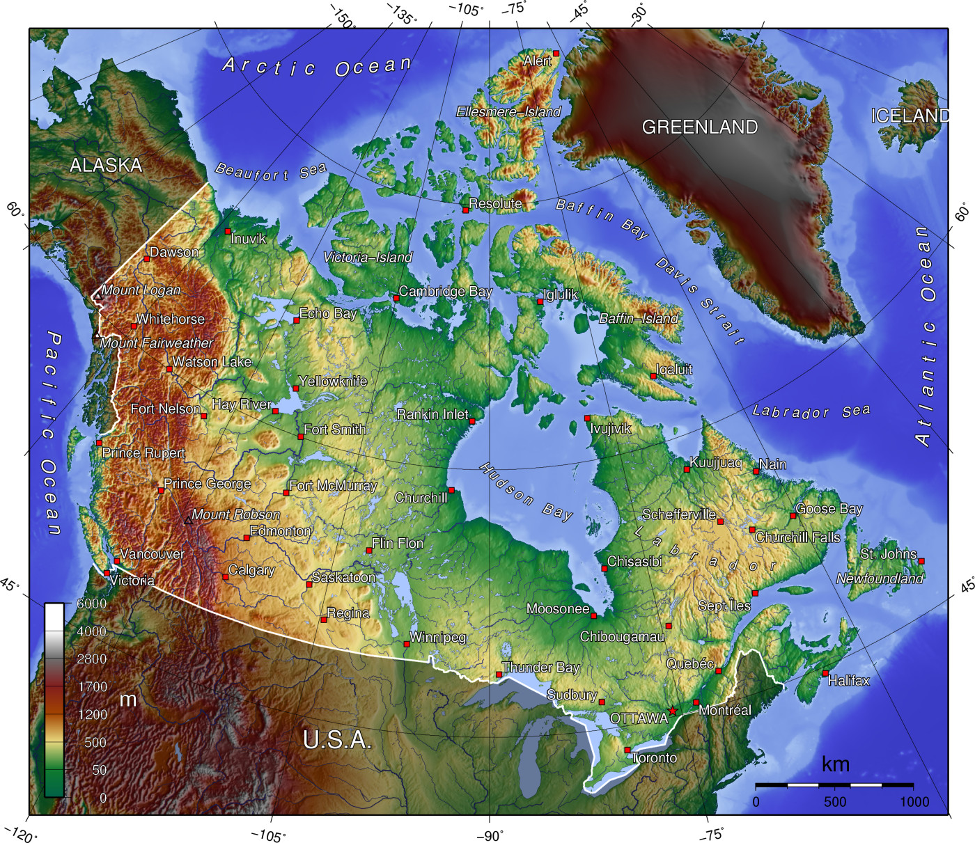 | १,४०० × १,२११ (७९१ KB) | smartcommons>Anchjo | '''This file was transfered from [http://en.wikipedia.org en.wikipedia.org]. The original file description page is (was) here.''' == Original description at [http://en.wikipedia.org en] == {{GFDL-GMT}} [[:de:Bild:Kanada_topo |
चित्र का उपयोग
कोई भी ऐसा पृष्ठ नहीं है जो इस चित्र का प्रयोग कर रहा हो।
