सामग्री पर जाएँ

चित्र:Diagrama enclave exclave.svg

भारतपीडिया से

मूल फ़ाइल (SVG फ़ाइल, साधारणतः १,६०० × १,५०० पिक्सेल, फ़ाइल का आकार: ८१ KB)

यह फ़ाइल एक साझे भंडार से है और दूसरे परियोजनाओं द्वारा भी प्रयोग की जा सकती है। वहाँ पर इसका फ़ाइल विवरण पृष्ठ में मौजूद विवरण नीचे दिखाया गया है।

Guam(C)

सारांश

विवरणDiagrama enclave exclave.svg
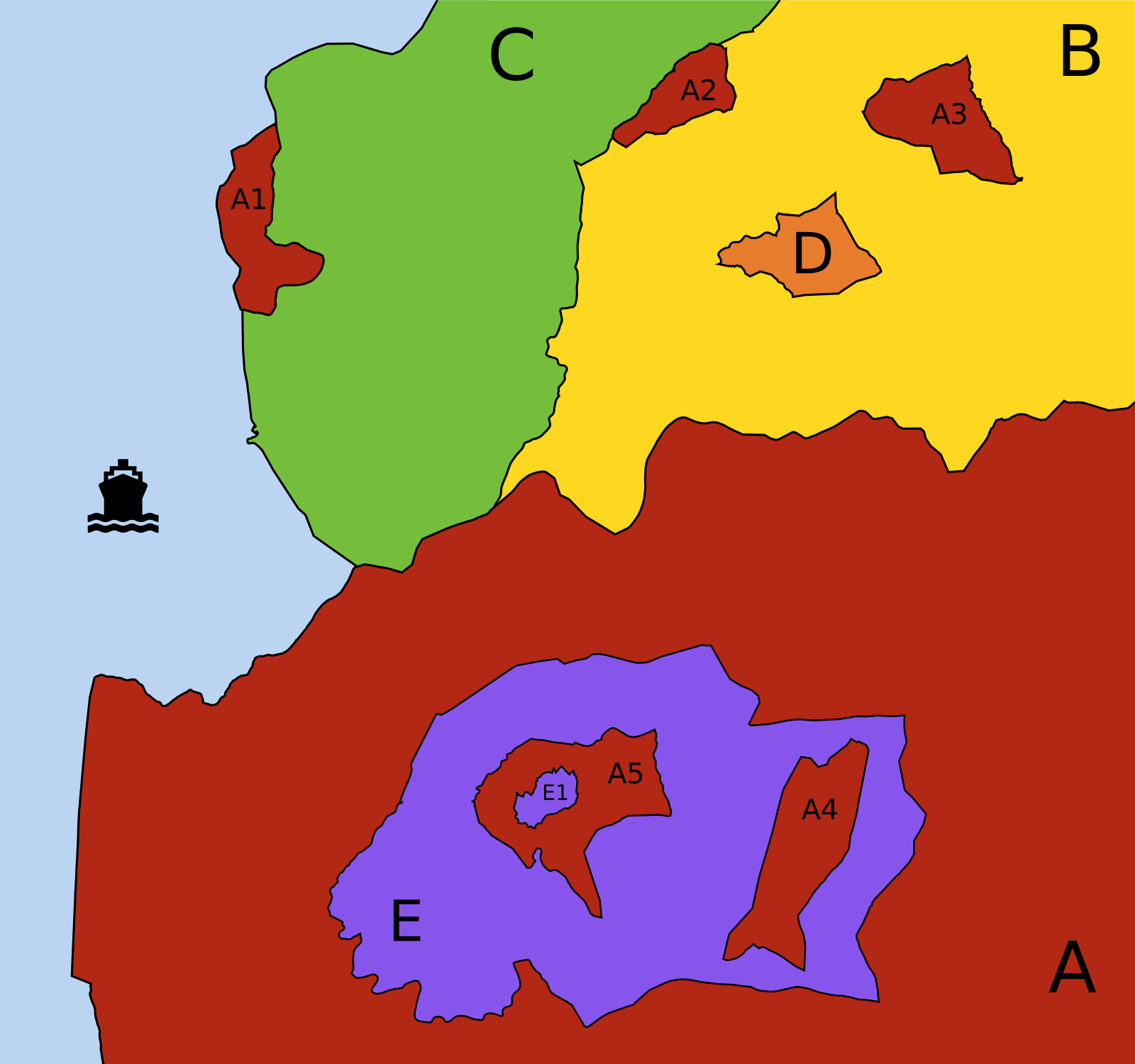
Português: Diagrama explicativo de descontinuidades territoriais: Enclaves e Exclaves.

Territórios (países, estados, municípios, etc.) diferentes são representados por cores e letras diferentes; parcelas de um mesmo território são representadas pela mesma cor e letra, sendo acrescentado um número diferente a cada uma das parcelas menores desse território (a parcela principal é identificada apenas pela letra).

  • A (vermelho):
    • tem 3 exclaves (A1, A2 e A3): é impossível ir da parcela principal de A a qualquer uma destas parcelas passando apenas por território de A; no entanto:
      • A1 não é um enclave: pode ir-se a A a A1 passando por C ou através do mar;
      • A2 não é um enclave: faz fronteira com mais do que um território "estrangeiro" (B e C);
      • A3 é um enclave: está totalmente rodeado por B;
    • tem 1 enclave (E): território "estrangeiro" totalmente rodeado por território de A;
    • tem 2 contra-enclaves, ou enclaves de segunda ordem (A4 e A5): territórios pertencentes a A encravados no interior do enclave E;
    • tem 1 contra-contra-enclave, ou enclave de terceira ordem (E1).
  • B (amarelo):
    • tem 2 enclaves (A3 e D).
  • C (verde):
    • território contínuo.
  • D (laranja):
    • é um território-enclave: é territorialmente contínuo, mas o seu território está totalmente rodeado por um único território "estrangeiro" (B).
  • E (lilás):
    • é um território-enclave: está encravado em A;
    • tem 2 enclaves (A4 e A5), que são contra-enclaves do território que circunda E;
    • tem 1 contra-enclave (E1), que é um contra-contra-enclave de A.


Em termos de Topologia Matemática, A e E são considerados superfícies desconexas e B, C e D são considerados superfícies conexas. No entanto, C e D são ainda considerados superfícies simplesmente conexas, enquanto B não o é (tem género 2, o número de "buracos" existentes em B).
English: Explicative diagram of territorial discontinuities: Enclaves and Exclaves.

Different territories (countries, states, counties, municipalities, etc.) are represented by different colours and letters; separated parts of the same territory are represented by the same colour and letter, with a different number added to each smaller part of that territory (the main part is identified by the letter only).

  • A (red):
    • has 3 exclaves (A1, A2 and A3): it is impossible to go from the main part A to any of these pasts going only through territory of A; however:
      • A1 is not an enclave: you can go from A to A1 passing through C or through the sea;
      • A2 is not an enclave: it has land frontiers with more than one "foreign" territory (B and C);
      • A3 is an enclave: it is totally surrounded by B;
    • has 1 enclave (E): "foreign" territory totally surrounded by territory of A;
    • has 2 counter-enclaves, or second-order enclaves (A4 and A5): territories belonging to A which are encroached inside the enclave E;
    • has 1 counter-counter-enclave, or third-order enclave de (E1).
  • B (yellow):
    • has 2 enclaves (A3 and D).
  • C (green):
    • continuous territory.
  • D (orange):
    • is an enclaved territory: it is territorially continuous, but its territory is totally surrounded by a single "foreign" territory (B).
  • E (purple):
    • is an enclaved territory: it is encroached inside A;
    • has 2 enclaves (A4 and A5) which are counter-enclaves of the territory surrounding E;
    • has 1 counter-enclave (E1) which is a counter-counter-enclave of A.
In topological terms, A and E are considered non-connected surfaces, and B, C and D are considered connected surfaces. However, C and D are also considered simply connected surfaces, while B is not (it has genus 2, the number of "holes" in B).
दिनांक
स्रोत अपना कार्य + File:TransmetropoleNavette.svg (icon)
लेखक Gazilion

लाइसेंस

मैं, इस कार्य का/की कॉपीराइट धारक, इसे निम्न लाइसेंस के अंतर्गत प्रकाशित करता/करती हूँ:
Creative Commons CC-Zero इस फ़ाइल को क्रिएटिव कॉमन्स CC0 1.0 वैश्विक सार्वजनिक डोमेन समर्पण के अंतर्गत उपलब्ध कराया गया है।
कार्य को इस आलेख से संबद्ध करने वाले व्यक्ति ने पूरे विश्व में कॉपीराइट कानूनों के अंतर्गत कार्य पर कानून की अनुमोदित सीमा तक सभी संबंधित अधिकारों समेत अपने सभी अधिकार त्यागकर इसे सार्वजनिक डोमेन को समर्पित किया है। आप बिना अनुमति के कार्य की प्रतियाँ बना सकते हैं, इसे बदल और पुनः वितरित कर सकते हैं, और प्रदर्शित कर सकते हैं, वाणिज्यिक उद्देश्यों से भी।

http://creativecommons.org/publicdomain/zero/1.0/deed.enCC0Creative Commons Zero, Public Domain Dedicationfalsefalse

Captions

Add a one-line explanation of what this file represents
Explicative diagram of territorial discontinuities: Enclaves and Exclaves

१७ अप्रैल 2014

source of file अंग्रेज़ी

original creation by uploader अंग्रेज़ी

data size अंग्रेज़ी

८३,१३९ बाइट

media type अंग्रेज़ी

image/svg+xml

checksum अंग्रेज़ी

8779a5fe82f3d324229e630bd582b6b9c5698b1b

फ़ाइल का इतिहास

फ़ाइल पुराने समय में कैसी दिखती थी यह जानने के लिए दिनांक/समय पर क्लिक करें।

दिनांक/समयअंगूठाकारआकारसदस्यटिप्पणी
वर्तमान०७:२०, १८ अप्रैल २०१४०७:२०, १८ अप्रैल २०१४ के संस्करण के लिए अंगूठाकार१,६०० × १,५०० (८१ KB)smartcommons>GazilionEtiqueta do mar substituída por ícone, para permitir o uso multilingue.

कोई भी ऐसा पृष्ठ नहीं है जो इस चित्र का प्रयोग कर रहा हो।