चित्र:Diu map1729.jpg

मूल फ़ाइल (१,०२४ × ७६८ पिक्सेल, फ़ाइल का आकार: ३४५ KB, MIME प्रकार: image/jpeg)
सारांश
| विवरणDiu map1729.jpg |
"The East Indies" (South and Southeast Asia): *the whole map*: *northwest* (shown above); *northeast*; *southwest*; *southeast*; miniature maps mostly from 'The Universal Traveller' by Thomas Salmon, London, 1752 [1729], many with modern hand coloring:
A later map by Salmon from 'A New Geographical and Historical Grammar...' (W. Johnston, London), 1766: *"East Indies"*: *northwest*; *northeast*; *southwest*; *southeast*; *the South*
Views from 'The Universal Traveller', 1752 and other editions: General views =*Accra (Ghana)* =*"Africa" (allegorical)* =*Habits of the Americans* =*animal species* =*apes and chimps* =*Arabs and Negroes* =*an armillary sphere (1766)* =*"Asia" (allegorical)* =*Batavians* =*Batavians (2)* =*Borneans* =*Bornean town* =*Constantinople* =*fish species* =*Hormuz* =*Javanese* =*Jerusalem* =*Loango (Congo)* =*Persians* =*Potala Palace, Tibet* =*San Salvador (Congo)* =*Tartars*: *detail 1*; *detail 2* =*Eastern Tartars* =*Teneriffe* =*Tonkinese* =*Trier* =*Turks* =*Xavier (Guinea)* Views of Europe =*Amsterdam* =*Antiparos (Greece)* =*Antwerp* =*Augsburg* =*Basel* =*Berlin* =*Brussels* =*Cadiz* =*Cologne* =*Copenhagen* =*Dutch* =*Flushing (Netherloands)* =*Frankfurt* =*Geneva* =*Ghent* =*Greeks* =*Greek priests* =*Metz* =*Middelburg (Netherlands)* =*Munster* =*Nuremberg* =*Oxford University* =*Prague* =*Spaniards* =*Vienna* Views of China =*Ambassador conducted to an audience* =*Ambassadors meeting the Emperor in China* =*An Audience of Leave* =*a Banquet in China* =*Bells of Peking and Erfurt* =*a Bonze; a Husbandman* =*a plan of Canton* =*Canton* =*Catching wild ducks with turtle shells in China* =*Chinese barks* =*Chinese husbandmen* =*Chinese ladies* =*Chinese sepulchres* =*the Emperor of China* =*Fishing with traps in China* =*the Five Horse Heads mountains* =*the Flying Bridge on the Whang-ho* =*a Fortress in China* =*Fu Chew Fu* =*the Great Wall of China* =*Hu Kew Hyen (Macau)* =*the Imperial Throne of China* =*Kon Jan Fiam temple* =*Nanking*; *a detail* =*Nan Yang* =*Paulinshi temple*; *a caption* =*Peking*; *detail 1*; *detail 2*; *detail 3* =*Peking observatory* =*Porcelain tower at Nanking* =*Sang Wan Hab mountains* =*Shau Chew* =*Silk manufacture in China* =*A Street in China* =*Supreme Imperial Hall of Audience* =*Temple in China (1)* =*Temple in China (2)* =*Temple images in China* =*Temple interior in China* =*Tong-chew*; *a detail* =*Tyen Tsing Wey fortress* See also: *images from "Modern History," 1732* |
|||||
| दिनांक | ||||||
| स्रोत | http://www.columbia.edu/itc/mealac/pritchett/00maplinks/mughal/salmonmaps/salmonmaps.html#madras | |||||
| लेखक | Thomas Salmon | |||||
| अनुमति (इस फ़ाइल का पुनः उपयोग करना) |
|
|||||


Captions
फ़ाइल का इतिहास
फ़ाइल पुराने समय में कैसी दिखती थी यह जानने के लिए दिनांक/समय पर क्लिक करें।
| दिनांक/समय | अंगूठाकार | आकार | सदस्य | टिप्पणी | |
|---|---|---|---|---|---|
| वर्तमान | १९:१८, १३ अक्टूबर २००७ | 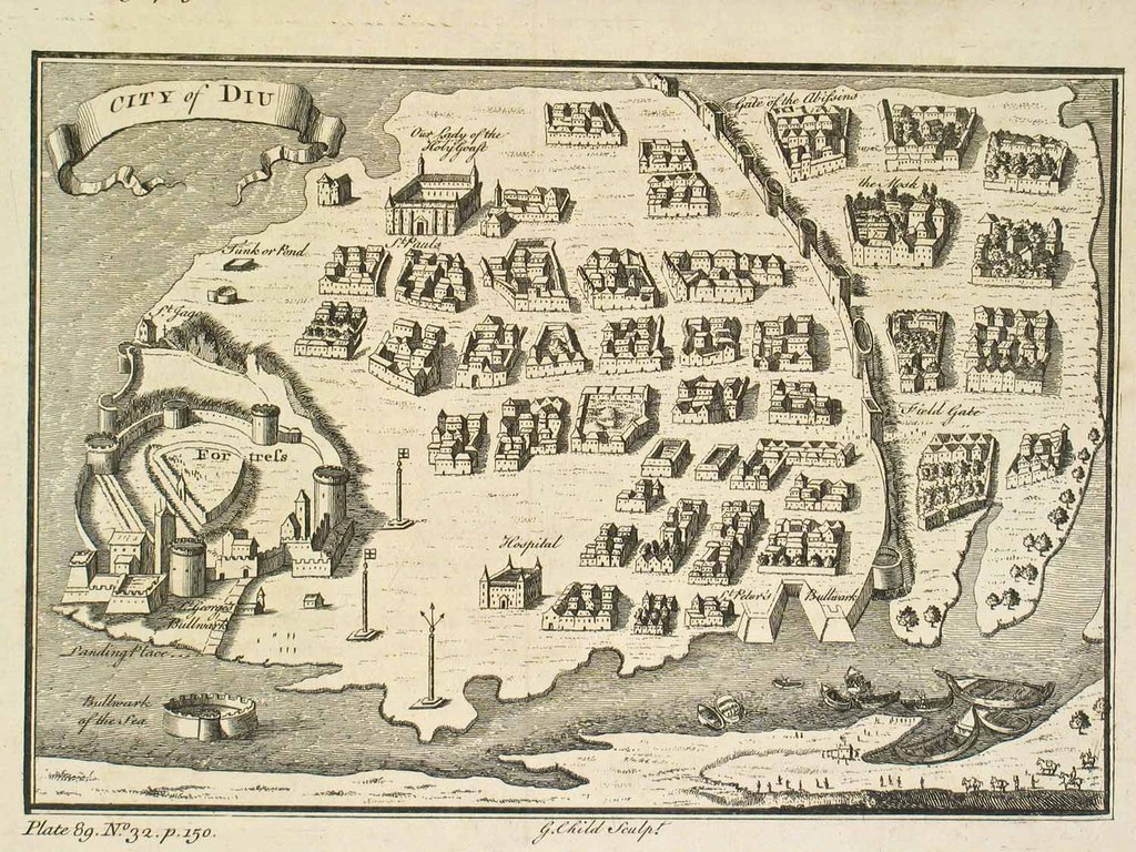 | १,०२४ × ७६८ (३४५ KB) | smartcommons>Aotearoa | {{Information |Description=Map of Diu, 1729 |Source= |Date= |Author= |Permission= |other_versions= }} |
चित्र का उपयोग
कोई भी ऐसा पृष्ठ नहीं है जो इस चित्र का प्रयोग कर रहा हो।
