चित्र:Himalayas Map.png

इस पूर्वावलोकन का आकार: २२० × १५६ पिक्सेल। दूसरे रेसोल्यूशन्स: ३२० × २२७ पिक्सेल | ७६१ × ५३९ पिक्सेल।
मूल फ़ाइल (७६१ × ५३९ पिक्सेल, फ़ाइल का आकार: ३५६ KB, MIME प्रकार: image/png)

सारांश
| विवरणHimalayas Map.png |
English: This is a map of the Himalayas that I cobbled together based on the information from a dozen surprisingly less than adequate maps of the region. The background topographical map is based off of the commons maps File:Topographic90deg N0E0.png and File:Topographic90deg N0E90.png. The locations of the countries are based off of looking at other maps, mostly at Wikipedia. They are for putting the range into a regional perspective and are not to be taken as definitive geopolitical boundaries. The rest is just done in Paint.NET, adding text, drawing lines, and then upping the darnkess on the area outside the mountain range. If I messed up, or you think you could do a better job, just do it! The method is outlined here for a reason. I know this isn't perfect. I hope that one day someone comes along and makes it better. I hold no ego or attachment to this work. The article needed a map, I gave it a map. |
| दिनांक | (UTC) |
| स्रोत | See the description section. |
| लेखक | Essentially, me. See the description section. |
| अनुमति (इस फ़ाइल का पुनः उपयोग करना) |
Public domain, feel free to pick it apart, label it, or replace it entirely if you find a better one. Just keep a local copy if you feel the urge to upload this to commons. |
| दूसरे संस्करण | None. At the moment, this is the best we've got. That being said, please feel free to make a better one. |


लाइसेंस
| Public domainPublic domainfalsefalse |

|
इस कार्य को इसके लेखक, Sven Manguard द्वारा सार्वजनिक डोमेन में प्रकाशित किया गया है। यह पूरे विश्व में लागू होता है। कुछ देशों में यह कानूनी तौर पर नहीं हो सकता है; ऐसा हो तो: |
मूल अपलोड लॉग
en.wikipedia से कॉमन्स पर FtCG की मदद से ट्रांसफ़र किया गया है।
The original description page was here. All following user names refer to en.wikipedia.

| Date/Time | Dimensions | User | Comment |
|---|---|---|---|
| 04:41, 27 November 2010 | 740 × 600 (374,989 bytes) | w:en:Sven Manguard (वार्ता | योगदान) | ({{Information |Description = This is a map of the Himalayas that I cobbled together based on the information from a dozen surprisingly less than adequate maps of the region. The background topographical map is based off of the commons maps [[:File:Top) |
Captions
Add a one-line explanation of what this file represents
Himalayas Map.
Расположение Гималаев на карте
फ़ाइल का इतिहास
फ़ाइल पुराने समय में कैसी दिखती थी यह जानने के लिए दिनांक/समय पर क्लिक करें।
| दिनांक/समय | अंगूठाकार | आकार | सदस्य | टिप्पणी | |
|---|---|---|---|---|---|
| वर्तमान | १९:३९, १० अगस्त २०१९ | 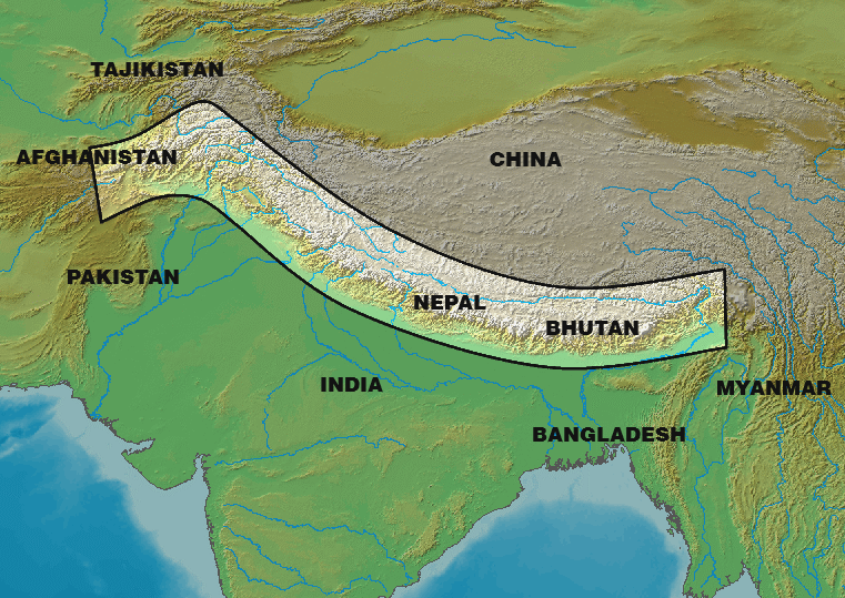 | ७६१ × ५३९ (३५६ KB) | smartcommons>ChandC | Font consistency, adding labels for Bangladesh and Myanmar as they're on the map too |
चित्र का उपयोग
कोई भी ऐसा पृष्ठ नहीं है जो इस चित्र का प्रयोग कर रहा हो।
