चित्र:Niger saharan medieval trade routes.PNG

इस पूर्वावलोकन का आकार: २२० × ८८ पिक्सेल। दूसरे रेसोल्यूशन्स: ३२० × १२८ पिक्सेल | ८१७ × ३२६ पिक्सेल।
मूल फ़ाइल (८१७ × ३२६ पिक्सेल, फ़ाइल का आकार: २६३ KB, MIME प्रकार: image/png)

|
इस map चित्र को वेक्टर ग्राफ़िक्स की मदद से एक SVG फ़ाइल के रूप में पुनः निर्मित किया जा सकता है। इसके कई फ़ायदे हैं; अधिक जानकारी के लिए Commons:Media for cleanup देखें। अगर इस चित्र का एक SVG रूप उपलब्ध है, कृपया उसे अपलोड करें और उसके बाद इस साँचे को
{{vector version available|नए चित्र का नाम}} से बदल दें।
SVG फ़ाइल का नाम "Niger saharan medieval trade routes.svg" रखना अनुशंसित है—ऐसा करने पर Vector version available (या Vva) साँचे पर नए चित्र का नाम वाले पैरामीटर की ज़रूरत नहीं पड़ेगी। |


सारांश
| विवरणNiger saharan medieval trade routes.PNG |
English: Map showing the main trans-Saharan caravan routes circa 1400. Also shown are the Ghana Empire (until the 13th century) and 13th – 15th century Mali Empire. Note the western route running from Djenné via Timbuktu to Sijilmassa. Present day Niger in yellow. Español: Mapa que muestra las principales rutas de caravanas transaharianas alrededor de 1400. También se muestran el Imperio de Ghana (hasta el siglo XIII) y el Imperio de Mali del siglo XIII-XV. Tenga en cuenta la ruta occidental que va desde Djenné a través de Tombuctú a Sijilmassa. En amarillo la extensión del Níger actual. |
| दिनांक | |
| स्रोत | self-made using The Gimp and Image:Africa historical traite.JPG |
| लेखक | T L Miles |
| अनुमति (इस फ़ाइल का पुनः उपयोग करना) |
Public Domain |

लाइसेंस
| Public domainPublic domainfalsefalse |

|
मैं, इस कार्य का/की कॉपीराइट धारक, इस कार्य को सार्वजनिक डोमेन में प्रकाशित करता/करती हूँ। यह पूरे विश्व में लागू होता है। कुछ देशों में यह कानूनी तौर पर नहीं हो सकता है; ऐसा हो तो: मैं सभी को इस कार्य का इस्तेमाल किसी भी उद्देश्य से, बिना किसी बाधाओं के इन शर्तों के कानून द्वारा अनिवार्य किए तक करने की अनुमति देता/देती हूँ। |
Captions
Add a one-line explanation of what this file represents
फ़ाइल का इतिहास
फ़ाइल पुराने समय में कैसी दिखती थी यह जानने के लिए दिनांक/समय पर क्लिक करें।
| दिनांक/समय | अंगूठाकार | आकार | सदस्य | टिप्पणी | |
|---|---|---|---|---|---|
| वर्तमान | ००:३९, १९ जनवरी २००८ | 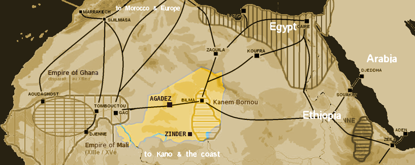 | ८१७ × ३२६ (२६३ KB) | smartcommons>T L Miles | {{Information |Description=Map of Medieval Saharan Trade routes, centerd on Niger |Source=self-made using The Gimp and Image:Africa historical traite.JPG |Date=2008-01-18 |Author= T L Miles |Permission=Public Domain |other_versions= } |
चित्र का उपयोग
कोई भी ऐसा पृष्ठ नहीं है जो इस चित्र का प्रयोग कर रहा हो।
