चित्र:NorthAmerica1762-83.png

मूल फ़ाइल (७८७ × ६०० पिक्सेल, फ़ाइल का आकार: ९० KB, MIME प्रकार: image/png)

|
इस historical map चित्र को वेक्टर ग्राफ़िक्स की मदद से एक SVG फ़ाइल के रूप में पुनः निर्मित किया जा सकता है। इसके कई फ़ायदे हैं; अधिक जानकारी के लिए Commons:Media for cleanup देखें। अगर इस चित्र का एक SVG रूप उपलब्ध है, कृपया उसे अपलोड करें और उसके बाद इस साँचे को
{{vector version available|नए चित्र का नाम}} से बदल दें।
SVG फ़ाइल का नाम "NorthAmerica1762-83.svg" रखना अनुशंसित है—ऐसा करने पर Vector version available (या Vva) साँचे पर नए चित्र का नाम वाले पैरामीटर की ज़रूरत नहीं पड़ेगी। |
सारांश
| विवरणNorthAmerica1762-83.png |
English: Map showing territorial gains of Britain and Spain following the French and Indian War.
Also shown are boundary changes within the territory the British had acquired between 1763 to 1783. Territorial lands held by the British before 1763 is shown in red, land gained by Britain in 1763 is shown in pink. The lands ceded to the Kingdom of Spain in secret during 1762 are in light yellow, and also set-off are the lands Britain promised to close to white settlement - a causus belli to many Americans leading to support for the American Revolution.العربية: خريطة تُظهر التغيُّرات الإقليميَّة في أمريكا الشماليَّة ومُكتسبات الإمبراطوريَّتين الإسپانيَّة والبريطانيَّة بُعيد انتهاء الحرب الفرنسيَّة الهنديَّة. |
| दिनांक | |
| स्रोत | इसपर आधारित अपना कार्य: BlankMap-USA-states-Canada-provinces.png by Roke |
| लेखक | Jon Platek |
| दूसरे संस्करण |
|


लाइसेंस


- आप खुलकर:
- बाँट सकते हैं – रचना की प्रतिलिपि बना सकते हैं, बाँँट सकते हैं और संचारित कर सकते हैं
- रीमिक्स कर सकते हैं – कार्य को अनुकूलित कर सकते हैं
- निम्नलिखित शर्तों के अंतर्गत:
- श्रेय – यह अनिवार्य है कि आप यथोचित श्रेय प्रदान करें, लाइसेंस की कड़ी प्रदान करें, और अगर कोई बदलाव हुए हों तो उन्हें इंगित करें। आप ऐसा किसी भी उचित तरीके से कर सकते हैं, लेकिन किसी भी तरह उससे यह नहीं संकेत नहीं किया जाना चाहिए कि लाइसेंसधारी द्वारा आपको अथवा आपके इस प्रयोग का समर्थन किया जा रहा हो।
- समानसांझा – यदि आप सामग्री को रीमिक्स करते हैं, बदलते हैं, या उस पर आधारित कुछ बनाते हैं, तो आपको अपने योगदान को समान या संगत लाइसेंस के तहत वितरित करना होगा।

|
इस दस्तावेज़ को Free Software Foundation द्वारा प्रकाशित GNU मुक्त प्रलेख लाइसेंस के संस्करण 1.2 या नए (बिना किसी अपरिवर्तनीय अनुभागों और अगले या पिछले आवरण के टेक्स्ट के) के अंतर्गत प्रतिलिपि बनाने, बाँटने और/या बदलने की अनुमति प्रदान की जाती है। इस लाइसेंस की एक प्रतिलिपि GNU मुक्त प्रलेख लाइसेंस नामक अनुभाग में शामिल है।http://www.gnu.org/copyleft/fdl.htmlGFDLGNU Free Documentation Licensetruetrue |
Notes
- The pink coloring specifically designates territory that Britain held without question after 1763; included are both areas that had been under full Spanish or French control and then lost, as well as areas disputedly claimed by Britain before 1763.
- The undefined boundary in the upper watershed of the Red River of the North was due to confusion at the time as to the location of the headwaters of the Mississippi River. (The source of the Mississippi was believed to have been further north than its actual location.)
- Dashed lines designate border changes within British-held territory outside of the thirteen colonies between 1763 and 1783.
- Both of the annexations shown, by West Florida in 1767 and by Quebec in 1774, were previously included in the Indian Reserve of 1763. The Indian Reserve boundaries shown on the map are only the boundaries of the reserve until 1783, except for adjustments to the boundary made by the 1768 Treaty of Fort Stanwix and other treaties, which are not shown.
CORRECTION that needs to be made: Nova Scotia is wrongly labelled. What is currently now Nova Scotia (and which includes what was then Acadia) is only the area indicated by the rightmost of the two indicator lines. The left area is pointing to what is now New Brunswick. These names and areas did not exist at that time. The area that is now Canada should be treated the same as the area that was the American colonies: show and label only the cities and towns, and do not provide labels for the currently existing states and provinces (i.e., the current individual American states are not labelled, so why are only two of the provinces labelled (and mislabelled at that)?).
Captions
फ़ाइल का इतिहास
फ़ाइल पुराने समय में कैसी दिखती थी यह जानने के लिए दिनांक/समय पर क्लिक करें।
| दिनांक/समय | अंगूठाकार | आकार | सदस्य | टिप्पणी | |
|---|---|---|---|---|---|
| वर्तमान | १०:४७, ५ सितम्बर २०११ | 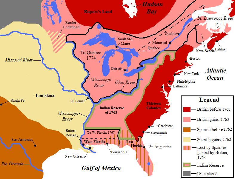 | ७८७ × ६०० (९० KB) | smartcommons>Creysmon07 | Changing contours of the lakes and the coasts of North America (made manually). |
चित्र का उपयोग
कोई भी ऐसा पृष्ठ नहीं है जो इस चित्र का प्रयोग कर रहा हो।
