चित्र:Olmec Heartland Overview 4.svg

मूल फ़ाइल (SVG फ़ाइल, साधारणतः १,७८८ × १,२७३ पिक्सेल, फ़ाइल का आकार: २५७ KB)
|


सारांश
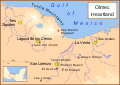
A map of the Olmec heartland. The yellow sites are known Olmec villages and towns. The smaller red dots mark locations where artifacts or art have been found unassociated with habitation. The river courses and shorelines are modern, as are the names (since we do not know the names the Olmecs used).
The Olmec heartland is the southern portion of Mexico's Gulf Coast region between the Tuxtla mountains and the Olmec archaeological site of La Venta, extending roughly 80 km (50 mi) inland from the Gulf of Mexico coastline at its deepest. It is today, as it was during the height of the Olmec civilization, a tropical lowland forest environment, crossed by meandering rivers.
The Olmec heartland was the home of the Olmec culture, which became widespread over Mesoamerica from about 1400 BCE until roughly 400 BCE.
The major heartland sites are:
- San Lorenzo Tenochtitlán
- La Venta
- Tres Zapotes
- Laguna de los Cerros - the least researched and least important of the major sites.
Smaller sites include:
- El Manatí, an Olmec sacrificial bog.
- El Azuzul, on the southern edge of the San Lorenzo area.
- San Andrés, near La Venta.
Important heartland finds not associated with any archaeological site include:
- "The Wrestler", a basalt statue found at Arroyo Sonso.
- Las Limas Monument 1, found by two children looking for somewhere to crack nuts.
- San Martín Pajapan Monument 1, found high on the slopes of San Martin Pajapan.
Note: This is another version of Image:Olmec Heartland Overview v2.svg
Other versions
Part of a series:
-
 Formative Period sites in Central Mexico
 -
 Formative Period sites in Southeastern Mesoamerica
 -
 Map of the Olmec Heartland
 -
 Classic era sites in Central Mexico
 -
 Site with early evidence for ballplaying
 -
 Western Mexico archaeological sites


References
- Arnold III, Philip J. (2002) Location of Isla Agaltepec in the Tuxtla Mountains, Veracruz, Mexico., in "Isla Agaltepec: Postclassic Occupation in the Tuxtla Mountains, Veracruz, México", accessed June 2007 (for elevations).
- Coe, Michael; Snow, Dean; Benson, Elizabeth; (1986) Atlas of Ancient America; Facts on File, New York, pp. 94-95, (for the locations of the sites).
- Diehl, Richard A. (2004) The Olmecs: America's First Civilization, Thames & Hudson, London, p.12.
- Rodríguez Martínez, Ma. del Carmen;Ortíz Ceballos, Ponciano; Coe, Michael D.; Diehl, Richard A.; Houston, Stephen D.; Taube, Karl A.; Calderón, Alfredo Delgado (2006) "Oldest Writing in the New World" in Science, Vol. 313. no. 5793, pp. 1610-1614 (for location of Cascajal).
- Pool, Christopher A. (२००७) Olmec Archaeology and Early Mesoamerica, कैम्ब्रिज: Cambridge University Press ISBN: 978-0-521-78882-3. (for location of Cobata and Llano del Jicaro)
लाइसेंस

|
इस दस्तावेज़ को Free Software Foundation द्वारा प्रकाशित GNU मुक्त प्रलेख लाइसेंस के संस्करण 1.2 या नए (बिना किसी अपरिवर्तनीय अनुभागों और अगले या पिछले आवरण के टेक्स्ट के) के अंतर्गत प्रतिलिपि बनाने, बाँटने और/या बदलने की अनुमति प्रदान की जाती है। इस लाइसेंस की एक प्रतिलिपि GNU मुक्त प्रलेख लाइसेंस नामक अनुभाग में शामिल है।http://www.gnu.org/copyleft/fdl.htmlGFDLGNU Free Documentation Licensetruetrue |


- आप खुलकर:
- बाँट सकते हैं – रचना की प्रतिलिपि बना सकते हैं, बाँँट सकते हैं और संचारित कर सकते हैं
- रीमिक्स कर सकते हैं – कार्य को अनुकूलित कर सकते हैं
- निम्नलिखित शर्तों के अंतर्गत:
- श्रेय – यह अनिवार्य है कि आप यथोचित श्रेय प्रदान करें, लाइसेंस की कड़ी प्रदान करें, और अगर कोई बदलाव हुए हों तो उन्हें इंगित करें। आप ऐसा किसी भी उचित तरीके से कर सकते हैं, लेकिन किसी भी तरह उससे यह नहीं संकेत नहीं किया जाना चाहिए कि लाइसेंसधारी द्वारा आपको अथवा आपके इस प्रयोग का समर्थन किया जा रहा हो।
Captions
फ़ाइल का इतिहास
फ़ाइल पुराने समय में कैसी दिखती थी यह जानने के लिए दिनांक/समय पर क्लिक करें।
| दिनांक/समय | अंगूठाकार | आकार | सदस्य | टिप्पणी | |
|---|---|---|---|---|---|
| वर्तमान | ०६:३३, ३० दिसम्बर २००७ |  | १,७८८ × १,२७३ (२५७ KB) | smartcommons>Madman2001 | Added two sites: Cobata and Cascajal, moved Llano del Jicaro west of Laguna de los Cerros, based on information in Pool. |
चित्र का उपयोग
कोई भी ऐसा पृष्ठ नहीं है जो इस चित्र का प्रयोग कर रहा हो।
