चित्र:Ph regions and provinces.svg

इस SVG फ़ाइल के PNG पूर्वावलोकन का आकार: २२० × ३२० पिक्सेल। दूसरा रेसोल्यूशन: १६५ × २४० पिक्सेल।
मूल फ़ाइल (SVG फ़ाइल, साधारणतः ४,२०० × ६,१०५ पिक्सेल, फ़ाइल का आकार: ३.०३ MB)
सारांश
| विवरणPh regions and provinces.svg |
English: Map of the Philippines showing the location of all the regions and provinces.
Notes: The map does not depict cities that are independent of any province. It also does not depict the status of Sabah, the Spratly Islands, and Scarborough Shoal as disputed Philippine territories. |
| दिनांक | |
| स्रोत | Own work, based on seav's Ph regions and provinces.png and Felipe Aira's File:PhlMapCit.svg |
| लेखक | HueMan1 |
| दूसरे संस्करण |
|


लाइसेंस
HueMan1, इस कार्य के कॉपीराइट धारक, इसे निम्न लाइसेंस के अंतर्गत प्रकाशित करते हैं:

|
इस दस्तावेज़ को Free Software Foundation द्वारा प्रकाशित GNU मुक्त प्रलेख लाइसेंस के संस्करण 1.2 या नए (बिना किसी अपरिवर्तनीय अनुभागों और अगले या पिछले आवरण के टेक्स्ट के) के अंतर्गत प्रतिलिपि बनाने, बाँटने और/या बदलने की अनुमति प्रदान की जाती है। इस लाइसेंस की एक प्रतिलिपि GNU मुक्त प्रलेख लाइसेंस नामक अनुभाग में शामिल है।http://www.gnu.org/copyleft/fdl.htmlGFDLGNU Free Documentation Licensetruetrue |
Captions
Add a one-line explanation of what this file represents
फ़ाइल का इतिहास
फ़ाइल पुराने समय में कैसी दिखती थी यह जानने के लिए दिनांक/समय पर क्लिक करें।
| दिनांक/समय | अंगूठाकार | आकार | सदस्य | टिप्पणी | |
|---|---|---|---|---|---|
| वर्तमान | १३:१७, २३ अक्टूबर २०२४ | 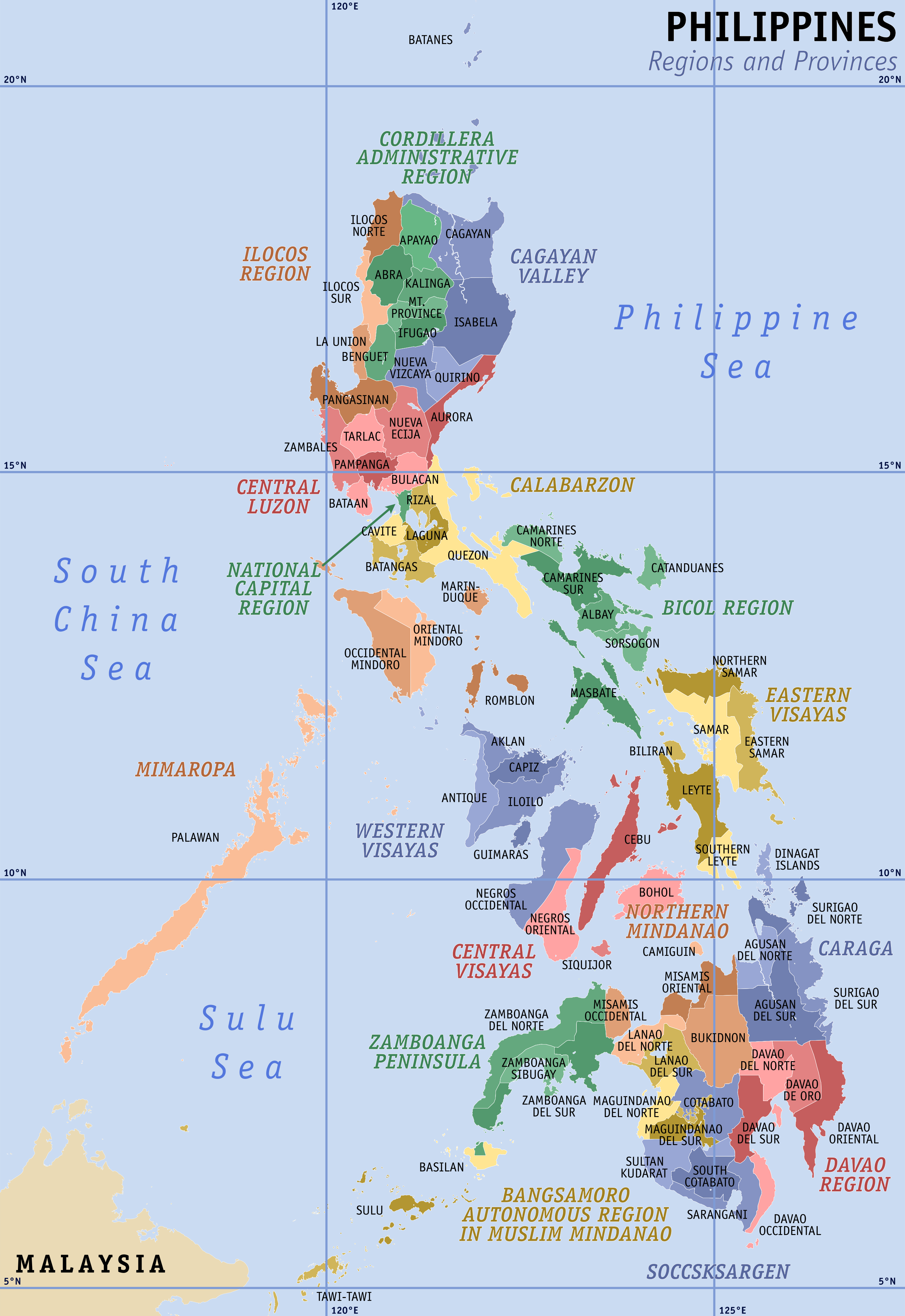 | ४,२०० × ६,१०५ (३.०३ MB) | smartcommons>Hariboneagle927 | NIR |
चित्र का उपयोग
कोई भी ऐसा पृष्ठ नहीं है जो इस चित्र का प्रयोग कर रहा हो।
