चित्र:Pope1880BengalPres2.jpg

इस पूर्वावलोकन का आकार: २२० × १७३ पिक्सेल। दूसरे रेसोल्यूशन्स: ३०६ × २४० पिक्सेल | १,२०० × ९४१ पिक्सेल।
मूल फ़ाइल (१,२०० × ९४१ पिक्सेल, फ़ाइल का आकार: २६३ KB, MIME प्रकार: image/jpeg)

सारांश
| विवरणPope1880BengalPres2.jpg |
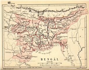
English: Map of "Bengal" from
Pope, G. U. (1880) Text-book of Indian History: Geographical Notes, Genealogical Tables, Examination Questions, London: W. H. Allen & Co. Pp. vii, 574, 16 maps
|
| दिनांक | |
| स्रोत | Pope, G. U. (1880) Text-book of Indian History: Geographical Notes, Genealogical Tables, Examination Questions, London: W. H. Allen & Co. Pp. vii, 574, 16 maps |
| लेखक | W. H. Allen and Co. |
लाइसेंस
| Public domainPublic domainfalsefalse |

|
This work is in the public domain in the United States because it was published (or registered with the U.S. Copyright Office) before January 1, 1931.
 Public domain works must be out of copyright in both the United States and in the source country of the work in order to be hosted on the Commons. If the work is not a U.S. work, the file must have an additional copyright tag indicating the copyright status in the source country.
Note: This tag should not be used for sound recordings.PD-1923Public domain in the United States//commons.wikimedia.org/wiki/File:Pope1880BengalPres2.jpg |
| Public domainPublic domainfalsefalse |
|
|
यह कार्य अपने स्रोत देश और दूसरे ऐसे देशों में सार्वजनिक डोमेन में है जहाँ कॉपीराइट की अवधि लेखक के जीवनकाल के साथ 100 वर्ष या उससे कम की होती है। You must also include a United States public domain tag to indicate why this work is in the public domain in the United States.
|
| इस फ़ाइल को कॉपीराइट कानूनों के अंतर्गत सभी संबंधित अधिकारों समेत ज्ञात सीमाओं से मुक्त पहचाना गया है। | |
https://creativecommons.org/publicdomain/mark/1.0/PDMCreative Commons Public Domain Mark 1.0falsefalse
| ऐनोटेशन्स InfoField | इस चित्र को ऐनोटेट किया गया है: कॉमन्स पर ऐनोटेशन्स देखें |

980
36
165
130
1200
941
Trade routes in Tibet
Captions
Add a one-line explanation of what this file represents
বরেন্দ্র এলাকা
फ़ाइल का इतिहास
फ़ाइल पुराने समय में कैसी दिखती थी यह जानने के लिए दिनांक/समय पर क्लिक करें।
| दिनांक/समय | अंगूठाकार | आकार | सदस्य | टिप्पणी | |
|---|---|---|---|---|---|
| वर्तमान | १७:०५, २ मार्च २०११ |  | १,२०० × ९४१ (२६३ KB) | smartcommons>MALLUS | {{Information |Description=Map of "Bengal" from {{Citation|last=Pope|first=G. U.|year=1880|title=Text-book of Indian History: Geographical Notes, Genealogical Tables, Examination Questions|publisher=London: W. H. Allen & Co. Pp. vii, 574, 16 maps}}. Sc |
चित्र का उपयोग
कोई भी ऐसा पृष्ठ नहीं है जो इस चित्र का प्रयोग कर रहा हो।
