चित्र:Rajendra map new.svg

इस SVG फ़ाइल के PNG पूर्वावलोकन का आकार: २२० × १५७ पिक्सेल। दूसरा रेसोल्यूशन: ३२० × २२९ पिक्सेल।
मूल फ़ाइल (SVG फ़ाइल, साधारणतः ४६६ × ३३३ पिक्सेल, फ़ाइल का आकार: २२० KB)

सारांश
| विवरणRajendra map new.svg |
per http://cw.routledge.com/textbooks/9780415485432/15.asp "THE CŌḶAS" by K. A. Nilakanta Sastri and other histories of South Asia consulted.
The file has several changes from the original. The map is corrected to show are of influence and direct control in Sri Lanka. Correction was based on the work of Spencer, G. (1976). The Politics of Plunder: The Cholas in Eleventh-Century Ceylon. The Journal of Asian Studies, 35(3), 405-419. doi:10.2307/2053272. The correction about the Chola influence in Malay areas is based on https://archive.org/details/earlykingdomsofi0000muno/page/118/mode/2up The influence added the area of Lamuri based on Tanjore inscription. Andaman is deleted leaving only Nicobar (information on Tanjore inscription). |
| दिनांक | (UTC) |
| स्रोत | |
| लेखक |
|
 |
यह एक सम्पादित चित्र है, जिसका मतलब है इसे इसके मौलिक संस्करण से डिजिटल रूप से बदला गया है। संशोधन: Redrew png as svg। मौलिक संस्करण यहाँ देखा जा सकता है: Rajendra map new.png:  । संशोधन Gregors द्वारा किए गए थे। । संशोधन Gregors द्वारा किए गए थे।
|
मैं, इस कार्य का/की कॉपीराइट धारक, इसे निम्न लाइसेंसों के अंतर्गत प्रकाशित करता/करती हूँ:
  
|
इस फ़ाइल को क्रिएटिव कॉमन्स श्रेय-समानसांझा 3.0 अनांतरित लाइसेंस के अंतर्गत लाइसेंस किया गया है। Subject to disclaimers. | |
| ||
| This licensing tag was added to this file as part of the GFDL licensing update.http://creativecommons.org/licenses/by-sa/3.0/CC BY-SA 3.0Creative Commons Attribution-Share Alike 3.0truetrue |

|
इस दस्तावेज़ को Free Software Foundation द्वारा प्रकाशित GNU मुक्त प्रलेख लाइसेंस के संस्करण 1.2 या नए (बिना किसी अपरिवर्तनीय अनुभागों और अगले या पिछले आवरण के टेक्स्ट के) के अंतर्गत प्रतिलिपि बनाने, बाँटने और/या बदलने की अनुमति प्रदान की जाती है। इस लाइसेंस की एक प्रतिलिपि GNU मुक्त प्रलेख लाइसेंस नामक अनुभाग में शामिल है।http://www.gnu.org/copyleft/fdl.htmlGFDLGNU Free Documentation Licensetruetrue |
आप अपना पसंद का लाइसेंस चुन सकते हैं।
मूल अपलोड लॉग
This image is a derivative work of the following images:
- File:Rajendra_map_new.png licensed with Cc-by-sa-3.0-migrated-with-disclaimers, GFDL-en, GFDL-user-en-with-disclaimers
- 2011-03-21T12:16:23Z Gregors 600x429 (102117 Bytes) Bitmap of svg that i will soon upload. ~~~~
- 2009-06-07T09:04:06Z Maukie 629x442 (215021 Bytes) {{Information |Description={{en|Map showing the extent of the [[:en:Chola empire|]] during [[:en:Rajendra Chola I|]] (c. 1030 CE)}} |Source=Transferred from [http://en.wikipedia.org en.wikipedia]; transfer was stated to be ma
Uploaded with derivativeFX
Captions
Add a one-line explanation of what this file represents
Extent of the Chola Empire.
சோழர்களின் ஆட்சி மற்றும் மக்கள் பற்றிய வரலாறு.
De omvang van het rijk van Rajendra Chola I, vorst van de Zuid-Indiase Chola's, rond het jaar 1030
फ़ाइल का इतिहास
फ़ाइल पुराने समय में कैसी दिखती थी यह जानने के लिए दिनांक/समय पर क्लिक करें।
| दिनांक/समय | अंगूठाकार | आकार | सदस्य | टिप्पणी | |
|---|---|---|---|---|---|
| वर्तमान | ०९:२४, २४ मई २०२४ | 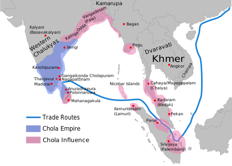 | ४६६ × ३३३ (२२० KB) | smartcommons>SKAG123 | Reverted to version as of 15:53, 12 May 2024 (UTC) Vandalism |
चित्र का उपयोग
कोई भी ऐसा पृष्ठ नहीं है जो इस चित्र का प्रयोग कर रहा हो।
