चित्र:Riogranderift sanluisbasin.png

मूल फ़ाइल (२,२८० × १,०७४ पिक्सेल, फ़ाइल का आकार: १.१७ MB, MIME प्रकार: image/png)

सारांश
utdlabrador, after B. Brister & R. Gries, Tertiary Stratigraphy and Tectonic Development of the Alamosa Basin (Northern San Luis Basin), Rio Grande Rift, South Central Colorado.
लाइसेंस
| Public domainPublic domainfalsefalse |

|
मैं, इस कार्य का/की कॉपीराइट धारक, इस कार्य को सार्वजनिक डोमेन में प्रकाशित करता/करती हूँ। यह पूरे विश्व में लागू होता है। कुछ देशों में यह कानूनी तौर पर नहीं हो सकता है; ऐसा हो तो: मैं सभी को इस कार्य का इस्तेमाल किसी भी उद्देश्य से, बिना किसी बाधाओं के इन शर्तों के कानून द्वारा अनिवार्य किए तक करने की अनुमति देता/देती हूँ। |
FYI, the legend on this diagram has an error. The green color (2nd-youngest division shown) is labeled "Paleocene alluvium and sediments". However, the Paleocene Epoch is older than the Eocene and Oligocene-age layers shown on the map, so this cannot be the correct name for sediments in this upper layer. This color must represent Miocene + Pliocene sediments, which collectively are grouped as the rocks of the Neogene Period.
Captions
फ़ाइल का इतिहास
फ़ाइल पुराने समय में कैसी दिखती थी यह जानने के लिए दिनांक/समय पर क्लिक करें।
| दिनांक/समय | अंगूठाकार | आकार | सदस्य | टिप्पणी | |
|---|---|---|---|---|---|
| वर्तमान | १२:४२, ५ दिसम्बर २०१० | 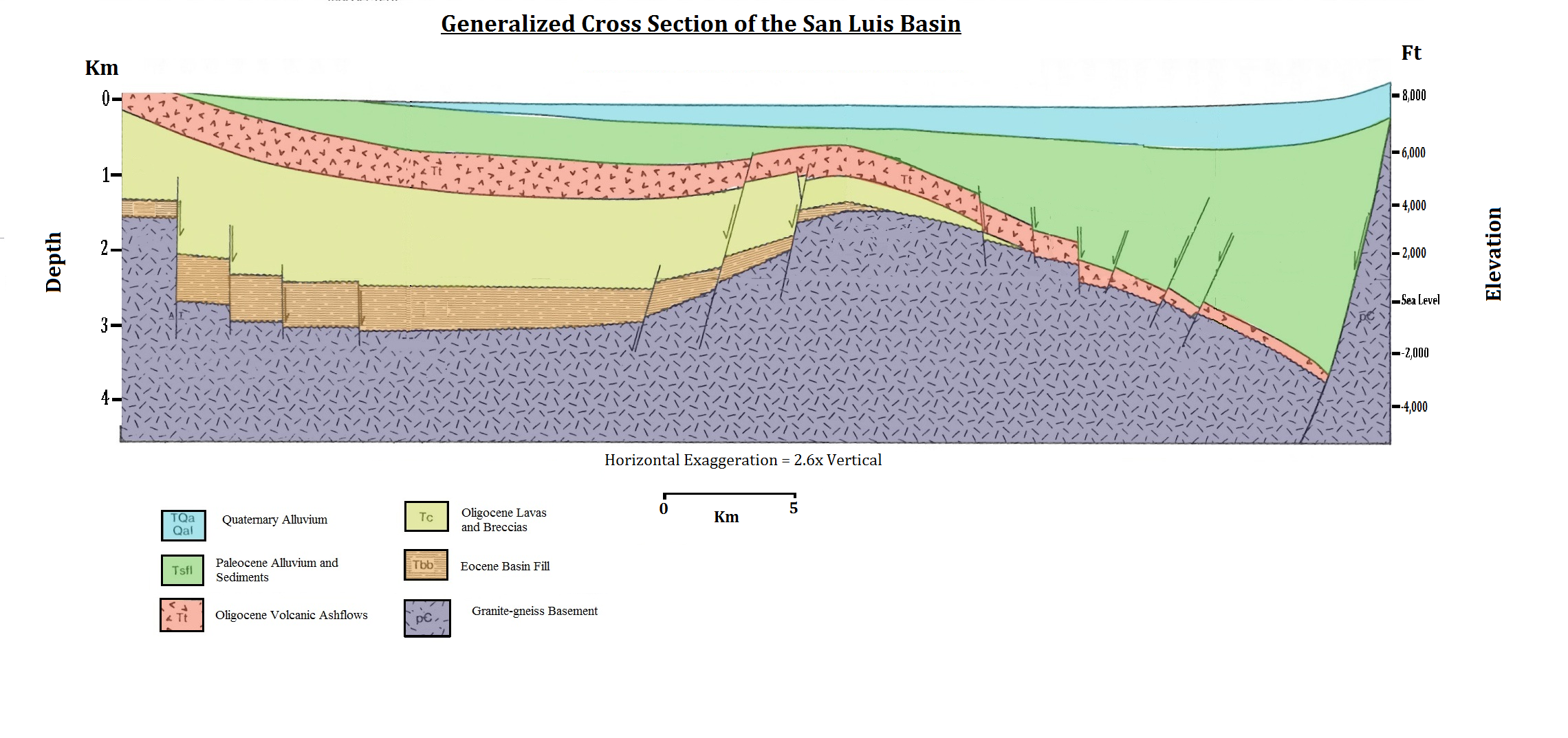 | २,२८० × १,०७४ (१.१७ MB) | smartcommons>Utdlabrador | utdlabrador, after B. Brister & R. Gries, '''Tertiary Stratigraphy and Tectonic Development of the Alamosa Basin (Northern San Luis Basin), Rio Grande Rift, South Central Colorado'''. |
चित्र का उपयोग
कोई भी ऐसा पृष्ठ नहीं है जो इस चित्र का प्रयोग कर रहा हो।
