सामग्री पर जाएँ

चित्र:Scotland population cartogram.svg

भारतपीडिया से

मूल फ़ाइल (SVG फ़ाइल, साधारणतः ५१२ × ८२३ पिक्सेल, फ़ाइल का आकार: ११८ KB)

यह फ़ाइल एक साझे भंडार से है और दूसरे परियोजनाओं द्वारा भी प्रयोग की जा सकती है। वहाँ पर इसका फ़ाइल विवरण पृष्ठ में मौजूद विवरण नीचे दिखाया गया है।

सारांश

विवरणScotland population cartogram.svg
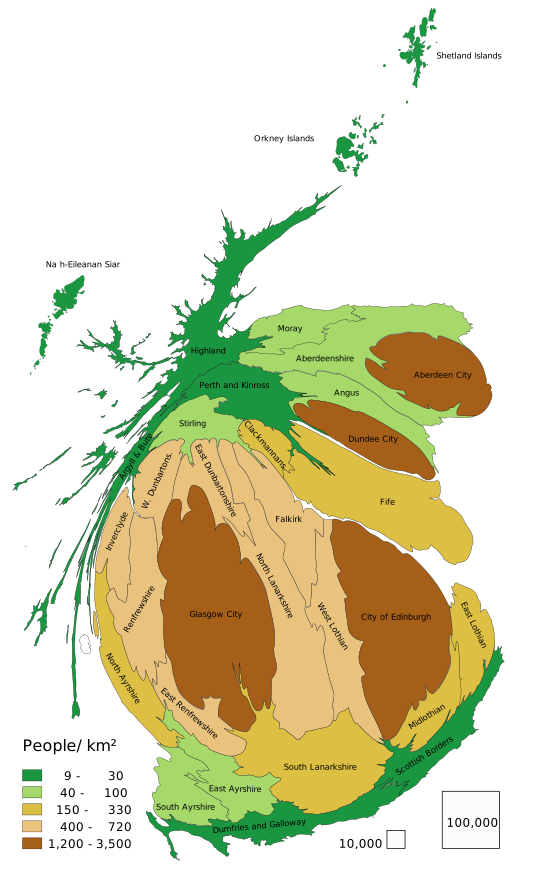
English: Scotland population cartogram. Size of council areas show their population - error standard deviation 4 %.
Polski: Kartogram populacji Szkocji. Wielkość council areas pokazuje liczbę mieszkańców - odchylenie standardowe błędu 4 %.
दिनांक
स्रोत

इसपर आधारित अपना कार्य:

Population Estimates for UK, England and Wales, Scotland and Northern Ireland - Office for National Statistics, 2015
Local Authority Districts (December 2016) Ultra Generalised Clipped Boundaries in Great Britain ONS Geography Linked Data Portal, under the Open Government Licence v3.0 (OGL v.3)
लेखक PawełS
SVG genesis
InfoField
 इस SVG का स्रोत कोड एक त्रुटि के कारण अमान्य है।
 इस W3Cअमान्य वेक्टर चित्र को Inkscape की मदद से बनाया गया था.
 and with QGIS.
Software: for mainland Scotland council areas (except Isle of Arran) ScapeToad (First grid 1 600; Diffusion grid size 1024; 8 iterations)

लाइसेंस

मैं, इस कार्य का/की कॉपीराइट धारक, इसे निम्न लाइसेंस के अंतर्गत प्रकाशित करता/करती हूँ:
w:hi:क्रिएटिव कॉमन्स
श्रेय समानसांझा
इस फ़ाइल को क्रिएटिव कॉमन्स श्रेय-समानसांझा 4.0 अंतर्राष्ट्रीय लाइसेंस के अंतर्गत लाइसेंस किया गया है।
आप खुलकर:
  • बाँट सकते हैं – रचना की प्रतिलिपि बना सकते हैं, बाँँट सकते हैं और संचारित कर सकते हैं
  • रीमिक्स कर सकते हैं – कार्य को अनुकूलित कर सकते हैं
निम्नलिखित शर्तों के अंतर्गत:
  • श्रेय – यह अनिवार्य है कि आप यथोचित श्रेय प्रदान करें, लाइसेंस की कड़ी प्रदान करें, और अगर कोई बदलाव हुए हों तो उन्हें इंगित करें। आप ऐसा किसी भी उचित तरीके से कर सकते हैं, लेकिन किसी भी तरह उससे यह नहीं संकेत नहीं किया जाना चाहिए कि लाइसेंसधारी द्वारा आपको अथवा आपके इस प्रयोग का समर्थन किया जा रहा हो।
  • समानसांझा – यदि आप सामग्री को रीमिक्स करते हैं, बदलते हैं, या उस पर आधारित कुछ बनाते हैं, तो आपको अपने योगदान को समान या संगत लाइसेंस के तहत वितरित करना होगा।
https://creativecommons.org/licenses/by-sa/4.0CC BY-SA 4.0 Creative Commons Attribution-Share Alike 4.0 truetrue
This file is licensed under the United Kingdom Open Government Licence v3.0.
You are free to:
  • copy, publish, distribute and transmit the Information;
  • adapt the Information;
  • exploit the Information commercially and non-commercially for example, by combining it with other Information, or by including it in your own product or application.
You must, where you do any of the above:
  • acknowledge the source of the Information in your product or application by including or linking to any attribution statement specified by the Information Provider(s) and, where possible, provide a link to this licence;
  • If the Information Provider does not provide a specific attribution statement, you must use the following:
Contains public sector information licensed under the Open Government Licence v3.0.
This licence does NOT cover:
  • personal data in the Information;
  • Information that has not been accessed by way of publication or disclosure under information access legislation (including the Freedom of Information Acts for the UK and Scotland) by or with the consent of the Information Provider;
  • departmental or public sector organisation logos, crests and the Royal Arms except where they form an integral part of a document or dataset;
  • military insignia;
  • third party rights the Information Provider is not authorised to license;
  • other intellectual property rights, including patents, trade marks, and design rights; and
  • identity documents such as the British Passport.
Consult this guide for full details.
Note: Since 2010, almost all information owned by the UK Crown is offered for use and re-use under the Open Government Licence by authority of The Controller of His Majesty's Stationery Office.info
See also: Meta for information on usage on Wikimedia wikis.
Open Government License 3OGL 3http://www.nationalarchives.gov.uk/doc/open-government-licence/version/3true

العربية  Deutsch  English  français  日本語  한국어  русский  中文  +/−

Captions

Add a one-line explanation of what this file represents

Items portrayed in this file

चित्रण

२२ मार्च 2017

data size अंग्रेज़ी

१,२१,२९३ बाइट

media type अंग्रेज़ी

image/svg+xml

checksum अंग्रेज़ी

69e0f236f53c491c984f08f7363e2e192117f183

फ़ाइल का इतिहास

फ़ाइल पुराने समय में कैसी दिखती थी यह जानने के लिए दिनांक/समय पर क्लिक करें।

दिनांक/समयअंगूठाकारआकारसदस्यटिप्पणी
वर्तमान२०:०६, १२ अक्टूबर २०२०२०:०६, १२ अक्टूबर २०२० के संस्करण के लिए अंगूठाकार५१२ × ८२३ (११८ KB)smartcommons>OctochampColours slightly adjusted to clarify the map and avoid confusion against a white or transparent background. White regions changed to an intermediate yellow between the green and brown already in use.

कोई भी ऐसा पृष्ठ नहीं है जो इस चित्र का प्रयोग कर रहा हो।