चित्र:TTPI-locatormap.png

इस पूर्वावलोकन का आकार: २२० × १५२ पिक्सेल। दूसरा रेसोल्यूशन: ३२६ × २२५ पिक्सेल।
मूल फ़ाइल (३२६ × २२५ पिक्सेल, फ़ाइल का आकार: ११ KB, MIME प्रकार: image/png)

|
इस historical map चित्र को वेक्टर ग्राफ़िक्स की मदद से एक SVG फ़ाइल के रूप में पुनः निर्मित किया जा सकता है। इसके कई फ़ायदे हैं; अधिक जानकारी के लिए Commons:Media for cleanup देखें। अगर इस चित्र का एक SVG रूप उपलब्ध है, कृपया उसे अपलोड करें और उसके बाद इस साँचे को
{{vector version available|नए चित्र का नाम}} से बदल दें।
SVG फ़ाइल का नाम "TTPI-locatormap.svg" रखना अनुशंसित है—ऐसा करने पर Vector version available (या Vva) साँचे पर नए चित्र का नाम वाले पैरामीटर की ज़रूरत नहीं पड़ेगी। |
| विवरणTTPI-locatormap.png |
Čeština: Mapa poručenského území Tichomořských ostrovů.
English: This is a locator map of the former Trust Territory of the Pacific Islands (TTPI). |
||||||||
| स्रोत | The map is based off of a locator map of Palau found on the German Wiki at de:Bild:Palau-Pos.png; it was created by German Wiki user de:Benutzer:Tzzzpfffand licensed under the GFDL. The changes made from the original map are various. The current boundries of the CNMI, Palau, FSM, and RMI are merged and Guam has it's own boundary due to the fact it never was a part of the TTPI. Boundries have been compared with Image:MapofTTPI.gif for accuracy. As the orginial image was licensed under the GFDL, I place my modification of the orginial map under the GFDL as well. | ||||||||
| लेखक |
|
||||||||
| अनुमति (इस फ़ाइल का पुनः उपयोग करना) |
|





Captions
Add a one-line explanation of what this file represents
Trust Territory of the Pacific Islands among the Pacific Ocean
ပစိဖိတ်သမုဒ္ဒရာအတွင်းရှိ ပစိဖိတ်ကျွန်းစုများ အစောင့်အရှောက်ခံဒေသ
फ़ाइल का इतिहास
फ़ाइल पुराने समय में कैसी दिखती थी यह जानने के लिए दिनांक/समय पर क्लिक करें।
| दिनांक/समय | अंगूठाकार | आकार | सदस्य | टिप्पणी | |
|---|---|---|---|---|---|
| वर्तमान | ०६:५७, १७ जून २०१० | 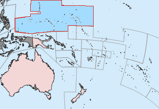 | ३२६ × २२५ (११ KB) | smartcommons>Ras67 | cropped |
चित्र का उपयोग
कोई भी ऐसा पृष्ठ नहीं है जो इस चित्र का प्रयोग कर रहा हो।
