Kannada literature during this period consisted of writings relating to the socio-religious developments of the Veerashaiva and Vaishnava faiths, and to a lesser extent to that of Jainism. Writing on secular topics was popular throughout this period. Authorship of these writings was not limited to poets and scholars alone. Significant literary contributions were made by members of the royal family, their ministers, army commanders of rank, nobility and the various subordinate rulers. In addition, a vast body of devotional folk literature was written by musical bards, mystics and saint-poets, influencing society in the empire. Writers of this period popularised use of the native metres: shatpadi (six-line verse), sangatya (compositions meant to be sung to the accompaniment of a musical instrument), and tripadi (three-line verse). (Full article...)
Tous Les Cinema du Monde section of the 2007 Cannes Film Festival. The film popularised the term Gandhigiri. Vidhu Vinod Chopra submitted the film as an independent entry for the 2007 Academy Award for Best Foreign Film. It was later remade in Telugu as Shankar Dada Zindabad (2007). (Full article...)
Temples built prior to Hoysala independence in the mid-12th century reflect significant Western Chalukya influences, while later temples retain some features salient to Western Chalukya architecture but have additional inventive decoration and ornamentation, features unique to Hoysala artisans. Some three hundred temples are known to survive in present-day Karnataka state and many more are mentioned in inscriptions, though only about seventy have been documented. The greatest concentration of these are in the Malnad (hill) districts, the native home of the Hoysala kings. (Full article...)
At the height of the Vijayanagara Empire, the Mysore and Coorg region was ruled by diverse chieftains, or rajas ("little kings"). Each raja had the right to govern a small region, but also an obligation to supply soldiers and annual tribute for the empire's needs. After the empire's fall and the subsequent eastward move of the diminished ruling family, many chieftains tried to loosen their imperial bonds and expand their realms. Sensing opportunity amidst the new uncertainty, various powers from the north invaded the region. Among these were the Sultanate of Bijapur to the northwest, the Sultanate of Golconda to the northeast, the newly-formed Maratha Empire farther northwest, and the major contemporary empire of India, the Mughal, which bounded all on the north. For much of the 17th century the tussles between the little kings and the big powers, and amongst the little kings, culminated in shifting sovereignties, loyalties, and borders. By the turn of the 18th century, the political landscape had become better defined: the northwestern hills were being ruled by the Nayaka rulers of Ikkeri, the southwestern—in the Western Ghats—by the Rajas of Coorg, the southern plains by the Wodeyar rulers of Mysore, all of which were Hindu dynasties; and the eastern and northeastern regions by the MuslimNawabs of Arcot and Sira. Of these, Ikkeri and Coorg were independent, Mysore, although much-expanded, was formally a Mughal dependency, and Arcot and Sira, Mughal subahs (or provinces). (Full article...)
A flotilla led by destroyers of the Indian Navy during Exercise Tropex 2023 In naval terminology, a destroyer is a fast, manoueverable, long-distance warship intended to escort larger vessels in a fleet, convoy or battle group and defend them against smaller, short-range attackers. Seventeen destroyers have served, or currently serve, in the Indian Navy. The navy operates 13 guided-missile destroyers from four classes: Visakhapatnam class, class, class, and class. Six other destroyers (three R class and three class) have been decommissioned and scrapped.
India did not have any destroyers of its own until 1949. The R-class INS Ranjit, built in the United Kingdom, was the first destroyer commissioned in the Indian Navy. Two more of the R-class were later commissioned. Three Hunt-class destroyers were commissioned in 1953 to succeed the R-class destroyers. These ships (all of which were built in the United Kingdom) were decommissioned by 1976, with the Hunt-class INS Godavari the last. (Full article...)
Image 3
Kajol in 2021 Kajol is an Indian actress who is known for her work in Hindi films. She made her screen debut in the 1992 film Bekhudi. She was noted for her performance and went on to sign the 1993 commercially successful thriller Baazigar opposite Shah Rukh Khan. She starred in the 1994 film Udhaar Ki Zindagi, which earned her critical acclaim. This was followed by a role in Yeh Dillagi alongside Akshay Kumar and Saif Ali Khan. Kajol featured in five films in 1995. She appeared briefly in the thrillerKaran Arjun, and played Simran, an NRI in Aditya Chopra’s romance Dilwale Dulhania Le Jayenge, both of which ranked among the highest-grossing Bollywood films of the year, and the success of the latter established her career in Bollywood. As of 2021, Dilwale Dulhania Le Jayenge is the longest-running Indian film. Also in 1995, she appeared in the box-office flops Hulchul and Gundaraj. Her only screen appearance of 1996 was in Bambai Ka Babu, a financial failure.
The high courts of India are the highest courts of appellate jurisdiction in each state and union territory of India. However, a high court exercises its original civil and criminal jurisdiction only if the subordinate courts are not authorized by law to try such matters for lack of peculiar or territorial jurisdiction. High courts may also enjoy original jurisdiction in certain matters, if so designated, especially by the constitution, a state law or union law.
The work of most high courts primarily consists of adjudicating on appeals from lower courts and writ petitions in terms of Articles 226 and 227 of the Constitution. Writ jurisdiction is also the original jurisdiction of a high court. (Full article...)
Image 6
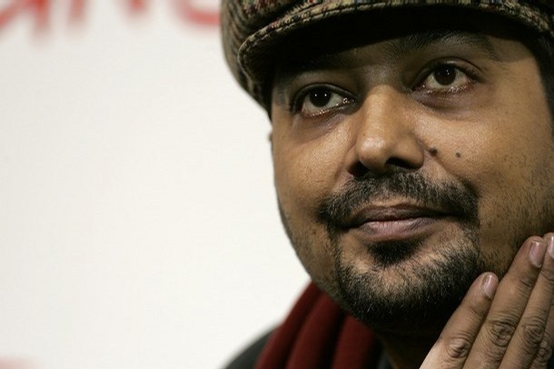
Kashyap attending the Rome Film Festival in 2007. Anurag Kashyap is an Indian filmmaker and actor, known for his work in Hindi cinema. After writing a television series Kabhie Kabhie (1997), Kashyap co-wrote Ram Gopal Varma's crime drama Satya (1998). He later wrote and directed a short television film, Last Train to Mahakali (1999), and made his feature film debut with the yet-unreleased film Paanch. He next directed Black Friday (2007), a film on the 1993 Bombay bombings. Its release was barred by India's Censor Board for two years, but was eventually released in 2007 to positive reviews. The same year, he directed the critical and commercial failure No Smoking. Return of Hanuman (2007), an animated film, was Kashyap's next directorial venture. In 2009, he directed Dev.D, a modern-day take on Sarat Chandra Chattopadhyay's Bengali novel Devdas, along with the political dramaGulaal. Despite positive reviews, the latter was a box-office failure.
The winner is given a "Swarna Kamal" (Golden Lotus) certificate and a cash prize of ₹3,00,000. Including ties and repeat winners, the NFDC has presented a total of 53 Best Direction awards to 34 different directors. Although Indian cinema produces films in more than twenty languages, the performances of films that have won awards are of nine languages: Bengali (16 awards), Malayalam (14 awards), Hindi (11 awards), Tamil (4 awards), English, Kannada and Marathi (3 awards each), Assamese and Punjabi (1 each). (Full article...)
Image 9
Trisha Krishnan in 2022 Trisha KrishnanTemplate:Ipf is an Indian actress known for her work primarily in Tamil and Telugu cinema. She is the only South Indian actress to have sustained a successful career as a leading actress for over two decades in Tamil cinema. She was first seen in 1999 in a minor supporting role in Jodi and later appeared in 2000 in the music video of Falguni Pathak's song 'Meri Chunar Udd Udd Jaye'.
The first project she accepted as a lead actress was Priyadarshan's Lesa Lesa but a delay in the film's release meant that her first appearance in a lead role was in Ameer's directorial debut Mounam Pesiyadhe in 2002, which was a commercial success. The following year, Trisha portrayed a woman battling a terminal illness in Manasellam (2003). Her next release was Hari's action film, Saamy (2003) in which she played a soft-spoken Brahmin girl and attracted praise for her performance, and the film became a major commercial and critical success, resulting in Trisha receiving new offers, including those from several high-budget productions. Lesa Lesa, which was to have been her debut as a lead actress, was released next, earned her the ITFA Best New Actress Award. She starred in Alai (2003) and the Tamil-Telugu bilingual film Enakku 20 Unakku 18 (2003) (Nee Manasu Naaku Telusu) were commercially unsuccessful. Trisha's next Telugu release, Varsham (2004), was a major commercial and critical success, earning her the first Filmfare Award for Best Actress-Telugu and more Telugu film offers. Trisha starred in Ghilli (2004) as a damsel in distress, and the film became a major critical and commercial success. She starred in Mani Ratnam's political drama Aayutha Ezhuthu (2004). She starred in Thirupaachi (2005), which became a major commercial success. Trisha played a village girl in the romantic comedy Nuvvostanante Nenoddantana (2005), a commercial and critical success that earned her a second Filmfare Award for Best Actress and a Nandi Award for Best Actress. Athadu (2005), Aaru (2005), Stalin (2006), were major commercial successes. She reprised the role in the Tamil remake Unakkum Enakkum (2006) which was also successful. She played the titular role in Pournami (2006). Aadavari Matalaku Arthale Verule (2007) was a critical and commercial success, earning Trisha her third Filmfare Award for Best Actress and the same year Kireedam (2007) was a commercial success. Krishna (2008) and King (2008) became blockbusters, while Bheema (2008) was commercially unsuccessful, and Kuruvi (2008) and Bujjigadu (2008) emerged as hits. In Abhiyum Naanum (2008), Trisha's performance was widely praised,' and earned her Tamil Nadu State Film Award and a Filmfare nomination for Best Actress. Her 2009 films Sarvam and Sankham did not do well and became average grossers. The following year, Vinnaithaandi Varuvaayaa (2010) was a major success and a career breakthrough for Trisha, earning her a Filmfare nomination for Best Actress. She made her debut in Hindi cinema with the film Khatta Meetha (2010) Upon release, the film received mixed reviews from critics and box office India declared it an average performer at the box office. However, it earned her nomination for a Filmfare Award for Best Female Debut. Her sole Telugu release that year was Namo Venkatesa. Both her 2011 releases –Teen Maar and Mankatha were successful. She had two releases in 2012, Bodyguard and Dammu were successful. Her two Tamil films in 2013 the mystery thriller Samar, and Endrendrum Punnagai (2013), which earned her a Filmfare nomination for Best Actress. Her sole release in 2014 was Power, which marked her debut in Kannada cinema was a commercial success. (Full article...)
Image 10
Players from the Royal Challengers Bangalore have recorded fifteen centuries so far, out of which five have been scored by Chris Gayle. In cricket, a batter reaches a century when he scores 100 runs or more in a single innings. A century is regarded as a landmark score for a batter, and his number of centuries is generally recorded in his career statistics. The Indian Premier League (IPL) is a professional league for Twenty20 cricket in India, which has been held annually since its first edition in 2008. In the fifteen seasons played so far, 74 centuries have been scored by 40 different batsmen out of which 20 are Indian players and the rest are overseas players. Players from eleven of the fifteen franchises have scored centuries, with the four franchises that have not had a player score a century for them being Pune Warriors India, Kochi Tuskers Kerala, Gujarat Lions & Gujarat Titans.
Jawaharlal Nehru Stadium as it appeared in July 2010, was the main venue for the 1982 Asiad. The 1982 Asian Games (also known as the IX Asiad)[a] was a multi-sport event held in Delhi, India, from 12 November to 4 December 1982. A total of 3,411 athletes from 33 National Olympic Committees (NOCs) participated in these games, competing in 147 events in 21 sports and 22 disciplines. The number of participating countries was the greatest in Asian Games history. Sport events of handball, equestrian, rowing and golf were included for the first time; while fencing and bowling were excluded. This medal table ranks the participating NOCs by the number of gold medals won by their athletes.
Athletes from 23 participating NOCs won at least one medal; athletes from 16 of these NOCs secured at least one gold. Athletes from China won 61 gold medals, the most of any nation at these Asiad, and led the gold-medal count for the first time in their Asiad history. Japan had won the greatest number of medals in previous editions of the Games. China first competed at the Asian Games in 1974, in Tehran, where it finished third. Athletes from both China and Japan won the most total medals with 153. China has secured the top medal spot in every Asiad since 1982. South Korea finished third in total medals. North Korea finished fifth in total medals, and fourth in the gold-medal count. Host nation India finished the games with 57 medals overall (13 gold, 19 silver and 25 bronze, its best performance since 1951), in fifth spot in terms of total gold medals. (Full article...)
Image 12
The portrait of young M. G. Ramachandran M. G. Ramachandran (11 January 1917 – 23 December 1987), popularly known by his initials MGR, was an Indian actor, film director and film producer who had an extensive career primarily in Tamil language films. He was called Chinnavar in film industry. After starring in numerous commercially successful films from the 1950s to the early 1970s, he has continued to hold a matinée idol status in Tamil Nadu. Ramachandran made his debut in Ellis R. Dungan's 1936 film Sathi Leelavathi, where he played a police inspector. He followed it with a string of minor appearances and supporting roles in many films, notably Ashok Kumar (1941), where he played the general of emperor Ashoka's army, and as a captain in Dungan's Meera (1945).
Ramachandran's breakthrough came with his first lead role in A. S. A. Sami's swashbuckler filmRajakumari (1947) where he played a villager who marries a princess. Based on the Arabian Nights, Rajakumari was a commercially successful venture. He established himself as an action hero akin to Errol Flynn and Douglas Fairbanks in Tamil cinema with Manthiri Kumari (1950) and Marmayogi (1951). Both films had political undertones which earned Ramachandran a Robin Hood persona of being a champion for the downtrodden. His performance as the caring brother Rajendran who tries to keep his family together in En Thangai (1952) earned him critical acclaim. In 1953, he made his debut in Malayalam films opposite B. S. Saroja in Genova. Ramachandran continued to play roles which enabled him to adopt his ideas of fighting injustice meted out to the poor such as an outlaw in Malaikkallan (1954), and Nadodi Mannan (1958). In the latter, he featured in dual roles, as a king and a commoner, for the first time in his career. Both Malaikkallan and Nadodi Mannan were commercially successful, becoming the highest-grossing films of their respective release years. In addition to social dramas, Ramachandran received positive feedback and commercial success for swashbuckler films such as Alibabavum 40 Thirudargalum (1956), the first South Indian full-length colour film, Madurai Veeran (1956), Chakravarthi Thirumagal and Mahadevi (both released in 1957). (Full article...)
Image 13
Zinta at a promotional event for Jaan-E-Mann in 2006
Preity Zinta (born 31 January 1975) is an Indian actress, film producer and entrepreneur. Her career began with Mani Ratnam's acclaimed drama Dil Se.. (1998), and in that same year she appeared in the box office hit Soldier. Both films won her the award for Best Female Debut at the 44th Filmfare Awards. Her performance in Dil Se.. also earned her a Best Supporting Actress nomination at the same ceremony, while Soldier won her three more Best Debut awards at other major ceremonies. Zinta received her first Filmfare nomination for Best Actress for her portrayal of a teenage single mother in Kya Kehna. She followed these films with several critically and commercially successful films, such as Mission Kashmir (2000) and Dil Chahta Hai (2001), and her performances in films like Chori Chori Chupke Chupke (2001), Dil Hai Tumhaara (2002) and Armaan (2003) were praised.
Dixit in 2019 Indian actress Madhuri Dixit made her acting debut in 1984 with Abodh where she portrayed a young bride. Dixit went on to appear in several films over the next three years, including the dramas Awara Baap (1985) and Swati (1986), though none of them garnered her much recognition. The role of Mohini in N. Chandra's action romance drama Tezaab (1988) proved to be a breakthrough for Dixit. The film went on to become the highest-grossing film of that year. For her performance, Dixit received a Best Actress nomination at Filmfare. She achieved further success by featuring as the female lead in several top-grossing action-dramas, including Ram Lakhan (1989) opposite Anil Kapoor, Tridev (1989) opposite Sunny Deol, and Kishen Kanhaiya (1990) opposite Anil Kapoor. The role of a wealthy brat in the 1990 romantic drama Dil earned Dixit her first Filmfare Award for Best Actress. The following year, she starred in another box-office hit Saajan, and won a second Best Actress award at Filmfare for portraying the role of a strong woman who rebels against her manipulative mother-in-law in the 1992 drama Beta.
She featured alongside Jackie Shroff and Sanjay Dutt in the action thriller Khalnayak (1993), one of the highest-grossing films of that year. Subsequently, she played an avenger in the drama Anjaam (1994) to positive reviews. Dixit's subsequent release was Sooraj Barjatya's Hum Aapke Hain Koun..! (1994), a family drama which emerged as the highest-grossing Bollywood film to that point. The following year, she featured in Raja (1995) which was a blockbuster film of that year and Yaraana in which she played a woman who attempts an escape from her abusive husband. Both of her releases in 1996—Rajkumar and Prem Granth—were financial failures. Dixit's portrayal of a headstrong dancer in Yash Chopra's 1997 romance Dil To Pagal Hai was a major success, earning her a fourth Filmfare Award for Best Actress. She garnered critical acclaim for her work in the dramas Mrityudand (1997), Wajood (1998) and Pukar (2000). She portrayed five roles in the experimental filmGaja Gamini (2000). (Full article...)
Image 15
Until the 18th century, Bombay consisted of seven islands separated by shallow sea. These seven islands were part of a larger archipelago in the Arabian sea, off the western coast of India. The date of city's founding is unclear—historians trace back urban settlement to the late 17th century after the British secured the seven islands from the Portuguese to establish a secure base in the region. The islands provided the British with a sheltered harbour for trade, in addition to a relatively sequestered location that reduced the chances of land-based attacks. Over the next two centuries, the British dominated the region, first securing the archipelago from the Portuguese, and later defeating the Marathas to secure the hinterland.
Vidya Balan's performance in Kahaani garnered her several awards and nominations Kahaani (transl.Story) is a 2012 Indian mysterythriller film directed and co-produced by Sujoy Ghosh. The film stars Vidya Balan as the protagonist, and features Parambrata Chatterjee, Nawazuddin Siddiqui, and Saswata Chatterjee in supporting roles. The film was edited by Namrata Rao, with the cinematography provided by Setu. Set in the city of Kolkata during the festivities of Durga Puja, Kahaani follows the life of a pregnant woman, Vidya Bagchi (Vidya Balan), in search of her husband, a man whose existence is denied by the people she encounters.
Made on a budget of ₹80 million (US$1.1 million), Kahaani was released on 9 March 2012 and grossed over ₹1.04 billion (US$15 million) worldwide after a 50-day theatrical run. The film garnered awards and nominations in several categories, with particular praise for its direction and the performance of the lead actress. As of 2014, the film has won 28 awards. (Full article...)
Image 17
Rabindranath Tagore was the first Indian and also the first non-European and the first Asian to be awarded with the Nobel Prize. He received the prize for Literature in 1913. The Nobel Prize is a set of annual international awards bestowed on "those who conferred the greatest benefit on humankind" in the fields of Physics, Chemistry, Physiology or Medicine, Literature, Peace and Economic Sciences, instituted by Alfred Nobel's last will, which specified that a part of his fortune be used to create the prizes. Each laureate (recipient) receives a gold medal, a diploma and a sum of money, which is decided annually by the Nobel Foundation. The Royal Swedish Academy of Sciences awards the Nobel Prize in Physics, the Nobel Prize in Chemistry and the Sveriges Riksbank Prize in Economic Sciences in Memory of Alfred Nobel; the Nobel Assembly at the Karolinska Institute awards the Nobel Prize in Physiology or Medicine; the Swedish Academy awards the Nobel Prize in Literature; and the Norwegian Nobel Committee awards the Nobel Peace Prize. They are widely recognised as one of the most prestigious honours awarded in the aforementioned fields.
First instituted in 1901, the Nobel Prize has been awarded to a total of 989 individuals (930 men and 59 women) and 30 organisations as of 2022[update]. Among the recipients, 12 are Indians of which 5 are Indian citizens and 7 are of Indian ancestry or residency. Rabindranath Tagore was the first Indian citizen to be awarded and also the first non-European and the first Asian to be awarded in 1913. Mother Teresa is the only woman among the list of recipients. Sri Aurobindo, the Indian poet, philosopher, nationalist and developer of Integral yoga, was nominated unsuccessfully for the Nobel Prize in Literature in 1943 and for the Nobel Peace Prize in 1950. (Full article...)
The first Indian to take a five-wicket haul was Mohammad Nissar who took 5 wickets for 93 runs during India's first Test, in June 1932 against England. Vaman Kumar, a leg spinner, was the next to achieve this feat. His figures of 5 wickets for 64 runs took India close to winning a match against Pakistan during the latter's tour of India in 1960–61. In December 1967, Syed Abid Ali took 6 wickets for 55 runs against Australia. The figures remain the best by an Indian fast bowler on debut. Narendra Hirwani's 8 wickets for 61 runs against the West Indies, in January 1988, are the best bowling figures by an Indian on Test debut. His aggregate of 16 wickets for 136 runs in the match are a record for any bowler on debut. As of February 2021, he is the only Indian cricketer to take ten or more wickets in a Test match on debut. (Full article...)
Image 20
Khan in 2015 Irrfan Khan (7 January 1967– 29 April 2020) was an Indian actor who worked in Indian and British-American films. His on-screen debut was a minor role in Mira Nair's Salaam Bombay! in 1988. He followed this with appearances in a variety of television shows in the late 1980s to 1990s including playing ʽAbd al-Qadir Badayuni in Bharat Ek Khoj (1988), Makhdoom Mohiuddin in Kahkashan (1991), Vladimir Lenin in Lal Ghas Per Neele Ghodey (1992), a dual role in Chandrakanta (1994), and Valmiki in Jai Hanuman (1997). Khan found his television work unfulfilling and considered quitting acting.
The prime minister of India is the chief executive of the Government of India and chair of the Union Council of Ministers. Although the president of India is the constitutional, nominal, and ceremonial head of state, in practice and ordinarily, the executive authority is vested in the prime minister and their chosen Council of Ministers. The prime minister is the leader elected by the party with a majority in the lower house of the Indian parliament, the Lok Sabha, which is the main legislative body in the Republic of India. The prime minister and their cabinet are at all times responsible to the Lok Sabha. The prime minister can be a member of the Lok Sabha or of the Rajya Sabha, the upper house of the parliament. The prime minister ranks third in the order of precedence.
The prime minister is appointed by the president of India; however, the prime minister has to enjoy the confidence of the majority of Lok Sabha members, who are directly electedevery five years, unless a prime minister resigns. The prime minister is the presiding member of the Council of Ministers of the Union government. The prime minister unilaterally controls the selection and dismissal of members of the council; and allocation of posts to members within the government. This council, which is collectively responsible to the Lok Sabha as per Article 75(3), assists the president regarding the operations under the latter's powers; however, by the virtue of Article 74 of the Constitution, such 'aid and advice' tendered by the council is binding. (Full article...)
Image 22
Bhatt in 2019 Alia Bhatt is a British actress of Indian descent who predominantly works in Hindi-language films. As a child, she made her debut in a minor role in her father Mahesh Bhatt's production Sangharsh (1999), as the younger version of star Preity Zinta's character. In 2012, Bhatt had her first lead role in Karan Johar's teen film Student of the Year, but her performance in it was not well-received. Two years later, she gained praise for playing a kidnapping victim in the road drama Highway (2014), winning the Filmfare Critics Award for Best Actress. In the same year, her starring roles in the commercially successful romances 2 States and Humpty Sharma Ki Dulhania, both produced under Johar's studio Dharma Productions, established her as a leading actress. She also sang the single "Samjhawan Unplugged" for the latter film's soundtrack.
Bhatt had three notable releases in 2016, Kapoor & Sons, Dear Zindagi, and Udta Punjab, in which she played young women in troubling circumstances. Her performance in the last of these won her the Filmfare Award for Best Actress. Following another romantic role in Badrinath Ki Dulhania (2017), she played a spy in the thriller Raazi (2018) and the volatile girlfriend of an aspiring rapper in the musical drama Gully Boy (2019). She won two more Best Actress awards at Filmfare for the latter two. This was followed by two poorly received films, Kalank (2019) and Sadak 2 (2020). The year 2022 proved key for Bhatt as she gained further success with a brief role in the Telugu-language period film RRR, and starring roles in the fantasy film Brahmāstra: Part One – Shiva and biopic Gangubai Kathiawadi, in which she starred as the titular prostitute; all three rank among the highest-grossing Indian films of the year. She won the National Film Award for Best Actress and her fourth Best Actress award at Filmfare for the last of these. She also produced and starred in the Netflix black comedy Darlings under her company Eternal Sunshine Productions. (Full article...)
Image 23
Kapoor Khan at an event for Bajrangi Bhaijaan in 2015 Kareena Kapoor is an Indian actress who has appeared in more than 66 Hindi films. She made her acting debut opposite Abhishek Bachchan in the 2000 drama Refugee, for which she won the Filmfare Award for Best Female Debut. The following year, she appeared in five films, including the romance Mujhe Kucch Kehna Hai, the thriller Ajnabee, and the ensemble melodrama Kabhi Khushi Kabhie Gham. The latter emerged as the highest-grossing Bollywood film in overseas to that point, and the success of these films established her in Bollywood. This success was followed by repetitive roles in a series of commercial failures.
Velaiilla Pattadhari (transl. Unemployed graduate) is a 2014 Indian Tamil-language comedy drama film written and filmed by Velraj while also making his directorial debut. The film featured Dhanush, who produced the film under his production company Wunderbar Films, and Amala Paul in the lead roles. Saranya Ponvannan, Samuthirakani, Vivek, Surbhi and Amitash Pradhan played supporting roles. The film's story focuses on Raghuvaran (Dhanush), a civil engineering graduate who is unemployed for four years, and his search for a job. As soon as he finds employment, he faces competition from Arun Subramaniam (Amitash), the head of a rival engineering company, for a government project contract. The rest of the film shows how Raghuvaran overcomes the obstacles set by Arun. The soundtrack and score were composed by Anirudh Ravichander while the editing was handled by M. V. Rajesh Kumar.
Produced on a budget of ₹80 million, Velaiilla Pattadhari was released on 18 July 2014 and received positive reviews. It was commercially successful, grossing ₹530 million worldwide. The film won 19 awards from 31 nominations; its direction, performances of the cast members and music have received the most attention from award groups. (Full article...)
Prince Siddhārtha leaving the palace on a horse during the Great Renunciation. Deities support the hooves of the horse. Approximately 2nd century, India The Great Renunciation or Great Departure (Sanskrit: mahābhiniṣkramaṇa; Pali: mahābhinikkhamana) is the traditional term for the departure of Gautama Buddha (c. 563–c. 483 BCE) from his palace at Kapilavastu to live a life as an ascetic (Script error: The function "langx" does not exist., Script error: The function "langx" does not exist.). It is called the Great Renunciation because it is regarded as a great sacrifice. Most accounts of this event can be found in post-canonical Buddhist texts from several Buddhist traditions, which are the most complete. These are, however, of a more mythological nature than the early texts. They exist in Pāli, Sanskrit and Chinese language.
According to these accounts, at the birth of Prince Siddhārtha Gautama, the Buddha-to-be, brahmin priests predicted that he would either become a world teacher or a world ruler. To prevent his son from turning to religious life, Prince Siddhārtha's father and rāja of the Śākya clan Śuddhodana did not allow him to see death or suffering, and distracted him with luxury. During his childhood, Prince Siddhārtha had a meditative experience, which made him realize the suffering (Script error: The function "langx" does not exist., Script error: The function "langx" does not exist.) inherent in all existence. He grew up and experienced a comfortable youth. But he continued to ponder about religious questions, and when he was 29 years old, he saw for the first time in his life what became known in Buddhism as the four sights: an old man, a sick person and a corpse, as well as an ascetic that inspired him. Shortly after, Prince Siddhārtha woke up at night and saw his female servants lying in unattractive poses, which shocked the prince. Moved by all the things he had experienced, the prince decided to leave the palace behind in the middle of the night against the will of his father, to live the life of an wandering ascetic, leaving behind his just-born son Rāhula and wife Yaśodharā. He traveled to the river Anomiya with his charioteer Chandaka and horse Kaṇṭhaka, and cut off his hair. Leaving his servant and horse behind, he journeyed into the woods and changed into monk's robes. Later, he met King Bimbisāra, who attempted to share his royal power with the former prince, but the now ascetic Gautama refused. (Full article...)
During a debate at the Oxford Union on 28 May 2015, the Indian Member of Parliament, diplomat and writer Shashi Tharoor delivered a speech supporting the motion "Britain owes reparations to her former colonies". Tharoor was the seventh speaker in the debate, the final speaker from the proposition, and spoke for about fifteen minutes. While criticising the opposition, he argued that British colonial rule damaged the Indian economy.
Tharoor began his speech by arguing that the economic progress of Britain from the 18th-century onwards was financed by the economic exploitation and de-industrialisation of British India. He cited other negative effects of colonial rule on India, such as famines and the mandatory contribution of Indians toward the British war effort during the First and Second World Wars. Tharoor argued that supposed benefits of British colonialism, such as railways and democracy, were either constructed for the purposes of furthering economic exploitation or devised by Indians themselves. He ended his speech by suggesting that Britain pay one pound sterlingper annum for the next two centuries as symbolic reparation. The side in favour of the motion won, with 185 votes to 56. (Full article...)
Image 5
Tipu's Tiger in the V&A Museum, London showing the prostrate European being attacked Tipu's Tiger or Tippu's Tiger is an eighteenth-century automaton or mechanical toy created for Tipu Sultan, the ruler of the Kingdom of Mysore in India. The carved and painted wood casing represents a tiger savaging a near life-size European man. Mechanisms inside the tiger and man's bodies make one hand of the man move, emit a wailing sound from his mouth and grunts from the tiger. In addition a flap on the side of the tiger folds down to reveal the keyboard of a small pipe organ with 18 notes.
The tiger was created for Tipu and makes use of his personal emblem of the tiger and expresses his hatred of his enemy, the British of the East India Company. The tiger was taken from his summer palace when East India Company troops stormed Tipu's capital in 1799. The Governor General, Lord Mornington sent the tiger to Britain initially intending it to be an exhibit in the Tower of London. First exhibited to the London public in 1808 in East India House, then the offices of the East India Company in London, it was later transferred to the Victoria and Albert Museum (V&A) in 1880 (accession number 2545(IS)). It now forms part of the permanent exhibit on the "Imperial courts of South India". From the moment it arrived in London to the present day, Tipu's Tiger has been a popular attraction to the public. (Full article...)
Physics Wallah Limited (PW) is an Indian educational technology company headquartered in Noida. It was started by Alakh Pandey as a YouTube channel in 2016 and was aimed at teaching physics for the JEE, NEET, and CBSE board examinations. As the channel began to gain more viewership, Pandey also started to post chemistry content. In 2020, Pandey, along with his co-founder, Prateek Maheshwari, established Physics Wallah as a company.
Physics Wallah became a unicorn company in 2022. As of September 2024. the company is valued at around $2.8 billion. Physics Wallah went public on the Indian exchanges with a ₹3,480 crore (US$490 million) initial public offering (IPO) in November 2025. (Full article...)
Image 11
File:2025 IPL logo.png The 2025 Indian Premier League, also known as IPL 18 and branded as TATA IPL 2025, was the 18th edition of the Indian Premier League, a professional Twenty20cricket league. The tournament featured 10 teams competing in 74 matches. It began on 22 March and was held across 13 venues before being suspended on 9 May due to the 2025 India–Pakistan crisis. The matches resumed from 17 May across six venues, with the final rescheduled from 25 May to 3 June.
They began their season by winning their opening fixture on 9 April, and went on to become the first team to qualify for the play-offs on 10 May. They beat the Kolkata Knight Riders in Qualifier 2 to reach the Final where they lost to the Chennai Super Kings by eight wickets to finish the season as runners-up. Williamson won the Orange Cap for scoring 735 runs in the IPL season. (Full article...)
... that Colonel Hugh Pettigrew observed that troops who thought that the Scottish Highlands resembled Waziristan on India's North West Frontier were "of little use to anyone"?



.svg)

 Featured article –











.jpg)


.jpg)


.jpg)


 Good article –




.jpg)


.jpg)

